Folsom Lake SRA and Folsom Powerhouse SHP Road and Trail Management Plan
Plan and CEQA are complete
The Folsom Lake SRA and Folsom Powerhouse SHP Road and Trail Management Plan (RTMP) and Initial Study/ Negative Declaration (IS/ND) CEQA are complete. Thank you for your participation in this process. State Parks looks forward to working with the public on the future implementation of recommendations in the RTMP.
The Documents include:
- Folsom Lake SRA and Folsom Powerhouse SHP Final RTMP (January 20, 2023)
- Folsom Lake SRA and Folsom Powerhouse SHP RTMP Final Appendices (January 20, 2023)
- Folsom Lake SRA and Folsom Powerhouse SHP RTMP Draft IS/ND (Sept 21st version)
- Folsom Lake SRA and Folsom Powerhouse SHP Final Initial Study/Negative Declaration with Revisions and Responses to Comments (January 20, 2023). This document contains the following:
- Master responses to comments received during the CEQA review period
- Responses to individual comments received during the CEQA review period
- Revisions to Draft IS/ND (Sept 21st version)
- Revisions to Public Draft RTMP (Sept 21st version)
- Appendix A: Comment Letters (all letters, in full)
A Notice of Determination was filed on 1/26/2023 with the State Clearinghouse.
Do you have suggestions or questions about the plan or process? Let us know at trails@parks.ca.gov.
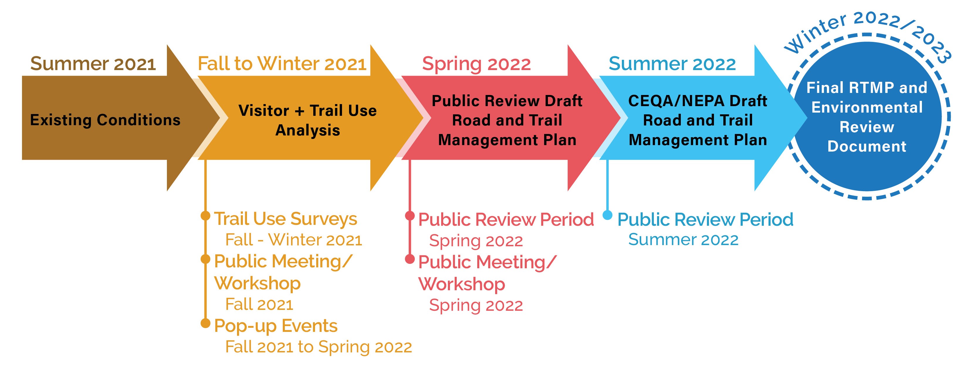
Planning Schedule
Road and Trail Management Plans
The purpose of a Road and Trail Management Plan (RTMP) is to provide specific and detailed management direction for roads and trails within a park unit, guiding the operation, maintenance, and development of the road and trail system. Following the broad programmatic goals and guidelines outlined in the General Plan, it will:
- identify new trail routes to be developed
- make decisions regarding whether to keep, eliminate, or re-align non-system (user-created) trails
- prioritize maintenance needs
- make recommendations on changes-in-use designations for specific trails
- identify trailhead needs and improvements
- identify educational and interpretative needs of the road and trail system
Folsom Lake SRA has over 120 miles of system trails and many miles of non-system trails. The need for an RTMP was identified in the Folsom Lake SRA General Plan and Resource Management Plan, which was approved in October 2009. The RTMP was initiated in 2012.
Planning Process
Data Collection
The first stage of the planning process is to develop an inventory of the road and trail system, including details such as permitted uses, features, and conditions. This information is used to evaluate road and trail conditions and associated impacts on natural and cultural resources. A comprehensive road and trail inventory was conducted at Folsom Lake SRA in 2013. Existing road and trail information was updated in 2021. The results of this inventory are illustrated in the maps below:
Existing Roads and Trails
This map set shows existing managed trails and roads in Folsom Lake SRA and Folsom Powerhouse State Historic Park (SHP) and their designated uses.
Erosion Severity
This map set shows the severity of erosion along roads and trails within Folsom Lake SRA and Folsom Powerhouse SHP.
Water Resources
This map set shows the potential for both trail and road features to impact water resources within Folsom Lake SRA and Folsom Powerhouse SHP and the condition of drainage structures along roads and trails.
Landscape Features
This map set identifies unstable landscapes, aquatic landscapes, and other significant landscapes along roads and trails within Folsom Lake SRA and Folsom Powerhouse SHP.
Road and Trail Structure Problem Severity
This map set shows structural road and trail problems within Folsom Lake SRA and Folsom Powerhouse SHP.
Public Input
Another critical part of the planning process is to get public input. Participation opportunities include surveys, focus groups, public workshops, and public meetings.
An onsite survey of trail users was conducted at Folsom Lake SRA from March 2013 through February 2014. The survey was designed to identify trail use patterns, gather input from trail users, and learn how trails might be improved. Survey collection occurred at 18 locations in the park, twice per season at each location - one weekday and one weekend day - resulting in 776 completed surveys. Survey results can be found here.
A subsequent web and app based trail use survey was conducted from October 26, 2021 to February 1, 2022. The web survey received responses from over 1500 users while the app survey received about 30 responses. Survey results can be found here.
Stakeholder focus group meetings were also conducted as part of the RTMP planning process for Folsom Lake SRA:
- Mountain Bike Interests Focus Group (3/27/2014) Meeting Notes
- Equestrian Interests Focus Group (7/1/2014) Meeting Notes
- Road Cycling and Paved Trail Interests Focus Group (11/17/2014) Meeting Notes
A public virtual meeting to provide updates on the planning process and receive public input was held on October 26, 2021. Review the presentation, summary, or archived recording.
Public comments were gathered from October 26, 2021 through February 1, 2022. A summary of these comments can be found here.
A public virtual meeting to review the draft plan and receive public comment was held on June 8, 2022. Review the presentation, summary, or archived recording.
A previous draft was available for public review and comment from May 23, 2022 to June 30, 2022, and we welcome you to review the categorized summary of comments received and summary of all comments received.
A final Draft of the Folsom Lake SRA and Folsom Powerhouse SHP Road and Trail Management Plan, which included a draft Initial Study /Negative Declaration CEQA document, was available for public review from September 22, 2022 to October 30, 2022. Comments and responses to these documents can be found in the Folsom Lake SRA and Folsom Powerhouse SHP Final Initial Study/Negative Declaration with Revisions and Responses to Comments and Appendix A: Comment Letters (all letters, in full). The Folsom Lake SRA and Folsom Powerhouse SHP RTMP Draft IS/ND (Sept 21st version).
Change-In-Use Assessment
Existing trails within a trail system are designated for specific trail uses, which are identified in a Superintendent's Order. Proposals to change the types of use (i.e. biking, equestrian, etc.) permitted on a trail are evaluated per the department's Change In Use (CIU) Process.
The Superintendent’s Order for Trail Use Policy at Folsom Lake SRA can be viewed here.
The following Folsom Lake SRA trails were evaluated per the CIU process in response to requests for bicycle use:
- Browns Ravine Trail to Old Salmon Falls (separate standalone decision from RTMP)
- Los Lagos Trail
- Middle Ridge Trail
- Monte Vista Trail
- Pioneer Express Trail (various segments)
- Shady Trail
- Snipes Pershing Ravine Trail
- Snowberry Trail
A summary of the CIU recommendations can be found in the appendices of the Draft Folsom Lake State Recreation Area and Folsom Powerhouse State Historic Park Road and Trail Management Plan or located here.
The CIU evaluation forms for each trail and associated trail segments can be found below:
- Los Lagos Trail
- Middle Ridge Trail
- Monte Vista Trails
- Pioneer Express Trail - Dike 5 to Dike 4
- Pioneer Express Trail - Dike 6 to Dike 5
- Pioneer Express Trail - Hazel Avenue to Nimbus Dam
- Pioneer Express Trail - Nimbus Dam to Mississippi Bar
- Pioneer Express Trail - San Juan Water to Beals Entrance
- Pioneer Express Trail - Truss Bridge to Folsom Crossing
- Pioneer Express Trail - Snipes Pershing Outlet to Truss Bridge
- Pioneer Express Trail - Beeks Bight to Sterling Pointe Connector Trail
- Pioneer Express Trail - Sterling Pointe Connector Trail to Rattlesnake Bar
- Pioneer Express Trail - Rattlesnake Bar to ASRA Boundary
- Shady Trail
- Snipes Pershing Ravine Trail
- Snowberry Trail
