South Yuba River State Park
The Park is currently OPEN.
Buttermilk Trail Temporary Closure
NOTICE: Buttermilk Bend Trail is closed until further notice due to a washout, which has made the trail extremely unstable and impassable. The trail is closed at the junction of the upper and lower Buttermilk Bend Trails. Stabilization of the trail will take significant reinforcement work and a reopening date is not determined at this time. We apologize for the inconvenience.Wildflower walks will still take place on weekends during the spring season (second weekend of March through Mother's Day).
The flows are cold due to snow melt and could potentially be greater and more dynamic than previous years; those recreating in and near the river are strongly advised to exercise caution. Typical flows in this part of the river for this time of year range from about 10 to 325 cfs. Peak flows may be as high as 4,000 to 6,000 cfs and potentially higher if there is a significant rain-on-snow event or multi-day heatwave accelerating snowmelt.
Know the Risks!
- Sudden immersion in cold water can stimulate the “gasp reflex,” causing an involuntary inhalation of air or water. It can even trigger cardiac arrest, temporary paralysis, hypothermia and drowning. Cold water also reduces body heat 25 to 30 times faster than air does at the same temperature and causes impairment that can be fatal.
- When faced with swift water, even the strongest swimmers can be easily overwhelmed.
- Prevention is the best way to save a person from drowning. By the time a person is struggling in the water, a rescue is extremely unlikely and places the rescuer at risk.
Buttermilk Bend Trail Closure
Trail Closure Announcement: Buttermilk Bend Trail
Attention Hikers and Park Guests,
We regret to inform you that the Buttermilk Bend Trail will be closed indefinitely due to major trail damage caused by recent trail washout. Your safety is our top priority, and given the extent of the damage, the trail is not safe for public use at this time.
We understand the disappointment this may cause to those who enjoy exploring Buttermilk Bend Trail, but please know that this closure is necessary to ensure the safety of all visitors. We urge everyone to refrain from accessing the trail until further notice.
In the meantime, we encourage you to explore alternative hiking trails in the area. There are many beautiful trails nearby that offer scenic experiences including the Virginia Turnpike Loop (easy), the 2.8-mile Point Defiance Loop at Bridgeport Crossing (moderate), the Hoyt Crossing Trail at Highway 49 crossing, the Independence Trail (east / upriver portion only) and the South Yuba River Recreation Trail connecting Purdon Crossing and Edwards Crossing. Our staff is available (530-432-2546) to provide recommendations and assistance in finding alternative routes for your outdoor adventures.
We sincerely apologize for any inconvenience this closure may cause and appreciate your cooperation and understanding as we work to address the damage and restore the Buttermilk Bend Trail to its safe and enjoyable condition.
Thank you for your patience and cooperation.
Independence Trail Partial Closure Due to Jones Fire
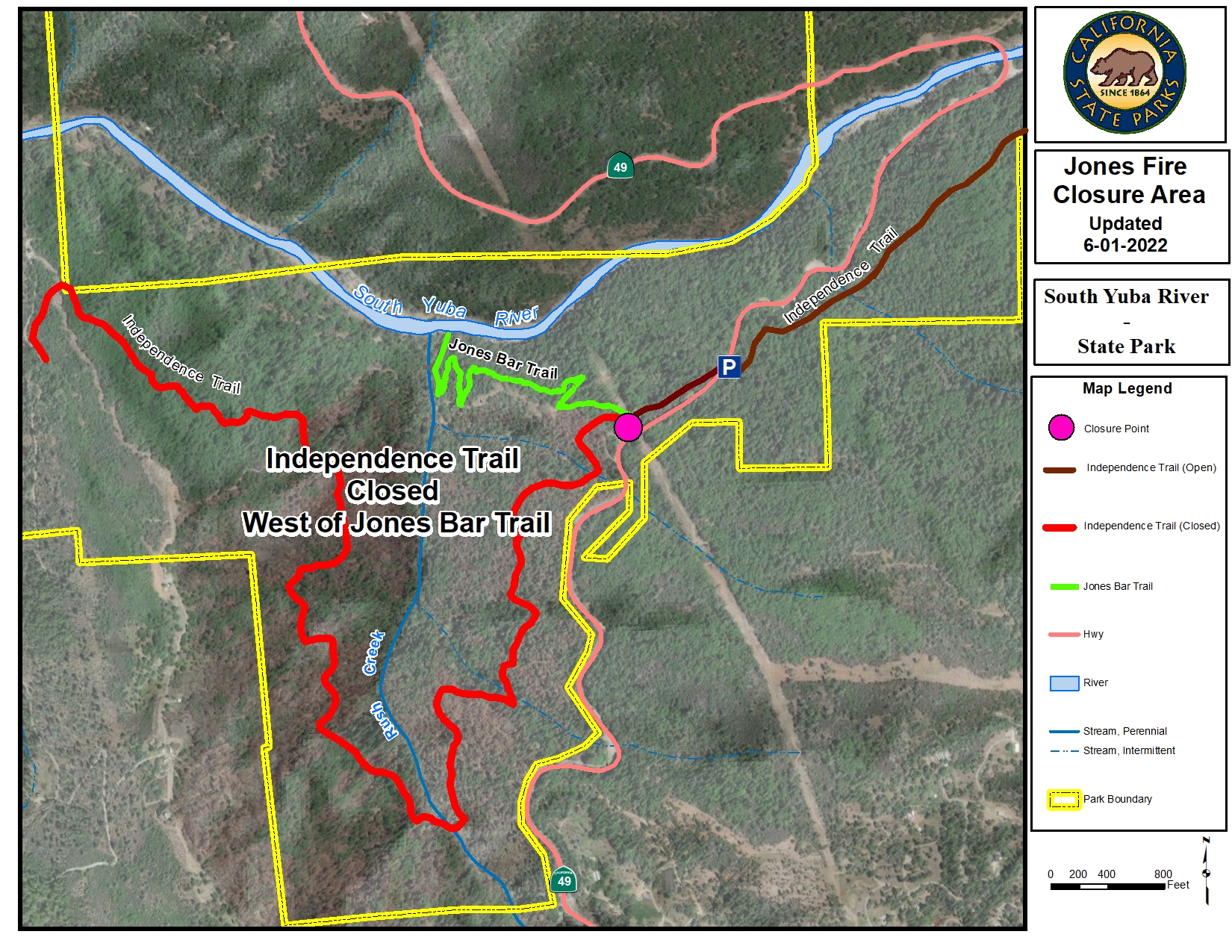
Independence Trail is partially closed to the public due to safety concerns and resource protection in the aftermath of the 2020 Jones Fire. A District Superintendent Order enacting the closure is currently in effect. The historic Independence Trail, off Highway 49 in western Nevada County, is closed west of the intersection with the newly re-aligned Jones Bar Trail to Rush Creek.
State Park crews are actively surveying the damage and working toward the restoration of this trail system. The work is extensive and may involve extended closure.
Thank you for your cooperation and understanding in staying off the trails for your own safety. If you have any further questions, please call the Sierra District Office at (530) 273-3884.

Bridgeport Covered Bridge Restoration Project
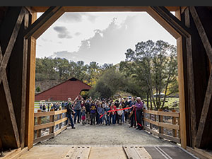
We welcome people to walk through the covered bridge and take a step back in time! The bridge connects hiking trails and the historic area, allowing visitors to relive the mining-era days of travel along the turnpike.This historic landmark reopened to the public on November 4th, 2021 after being closed for 10 years due to safety concerns. Preservation is a community effort, and would not have been possible without decades of community involvement. With the support of State Parks, Sierra Gold Parks Foundation, Nevada County, South Yuba River Citizens’ League, and the Nevada County Regional Chamber of Commerce, private citizens, and elected officials, Save Our Bridge gained the attention and eventual $6.9 million in funding to make this goal a reality. The rehabilitation project spanned mid-2019 through the fall of 2021 by Spectra Company and is an inspiring example how a community can come together to save an historical treasure for future generations.
Click here for the chronicled progress of the project.
Land Acknowledgement
California State Parks acknowledges the Nisenan People were here in this State Park since time immemorial. The Nisenan People are still here today, though they are nearly invisible.
The Sierra District of California State Parks includes their story in our interpretation and education here at the South Yuba River State Park. We understand we are on Nisenan Land and that the original Tribal Families have yet to recover from the near genocide of their people during the California Gold Rush.
California State Parks supports the Nevada City Rancheria Tribe in efforts to stabilize their people as well as the campaign to restore Tribal sovereignty through Federal Recognition.
Watch our interview with Nisenan Tribal Spokesperson, Shelly Covert recording here
Location-Directions:
South Yuba River State Park headquarters located at Bridgeport, 17660 Pleasant Valley Rd can be accessed from Highway 20 west of Grass Valley or from Higway 49 north of Nevada City. Remote portions of the park are accessible from Edwards Crossing, Purdon Crossing, and Highway 49.
The park:
This 20-mile portion of the South Yuba River canyon stretches from Malakoff Diggins State Historic Park to Bridgeport covered bridge. The area includes the longest single-span covered bridge in the world, the steep rugged canyon of the South Yuba River, and the Independence Trail - the first identified wheelchair-accessible wilderness trail in the country.
South Yuba River State Park offers many scenic vistas. Visitors can view swift moving water carving the granitic canyon that is peppered with seasonal native blooms in springtime, and experience refreshing swimming holes that dot the 20 mile length of the Yuba River in late summer. Along the length of the park, visitors can see several architectually different bridges spanning from the Gold Rush era to the mid-20th century.
Visitors can enjoy:
- swimming
- bird watching
- panning for gold
- wildflowers in the spring
- hiking in the historic gold country
- docent-led history, wildflower, birding, geology, and gold-panning tours are also offered at selected times throughout the year
Adventuresome hikers have a choice of trails ranging in difficulty, from the easiest (Independence Trail), to other more strenuous trails throughout the park. Click on the "Hiking" link above right to explore all the hiking trail options.
Caution:
Winter and Spring weather conditions can cause the trail to become muddy and impassable for wheelchairs. Call the park for trail condition information before you go.
Filming Videos and Still Photography in State Parks
 California State Parks thanks you for choosing our beautiful parks for your photographic activities and sharing the wonders of our park units with the world. However, in order to maintain the beauty of our parks and its natural and cultural resources, we require that all commercial, still and motion picture photographers obtain a film permit from the California Film Commission.
California State Parks requires an approved film permit for:
- All commercial still photography and videography
- Professional photographers offering services
- Student photo/film projects
- Professional development projects
Drones are not permitted unless a special permit is granted. Use the film and photography permit link below for contact information.
To learn more, please visit our blog here.
For specific film permit information at Empire Mine State Historic Park, Malakoff Diggins State Historic Park or South Yuba River State Park, please review Sierra Gold Sector Film Permit information.


