


Prairie City SVRA held an in-person and virtual stakeholder workshop to gather feedback on potential OHV route and trail development. The meeting was held on August 9, 2023, at the Prairie City SVRA Environmental Training Center. This included an existing park use map and the opportunities and constraints map for each zone along, with QR codes and physical copies of the survey for participants to take while attending the workshop. The survey was developed to address key issues in the Prairie City SVRA Road and Trail Management Plan using questions from the Trail Experience Survey conducted in 2018 as a starting point. The 2018 Trail Experience Survey asked questions pertaining to trail features that were desired and use types in each of the zones. The 2023 Community Feedback Survey expanded on these questions to gain a better understanding on other uses that may be desired by users and community members, addressed specific concerns in each of the zones, and additional features/uses that may be added.
Three pop-up events were conducted prior to the closing of the Community Feedback Survey. These events included visitor engagement at the interpretive booth at the popular Hangtown Motocross Classic on June 3, 2023, the El Dorado Hills Farmers Market held on July 30, 2023, and at Cal 4Wheel’s Sierra Trek, a family 4x4 event in Tahoe National Forest on August 11 and 12, 2023, where postcards were handed out that directed visitors to the project website to take the survey.
A second workshop was held at the Environmental Training Center located within the Prairie City SVRA at 13300 White Rock Road, Rancho Cordova, CA 95742, from 6:00 – 8:00 pm on Wednesday, January 24, 2024. This workshop presented draft recommendations where attendees were divided into working groups to discuss proposed recommendations as well as solicit new ideas. The public was also encouraged to complete a feedback form either during the workshop or later online. Access to this feedback form was also sent out to the project contact email list. Results of the feedback form can be accessed here.
California State Parks is working towards completion of the Prairie City SVRA Road and Trail Management Plan. Next steps include finalizing the proposed plan and environmental review of the proposed plan in compliance with CEQA (California Environmental Quality Act).
Do you have other suggestions about the RTMP? Let us know at trails@parks.ca.gov.
Workshop #1
Prairie City SVRA RTMP August Public Meeting:
Prairie City SVRA RTMP August Public Meeting – Virtual Workshop:
A second workshop was held at the Environmental Training Center located within the Prairie City SVRA at 13300 White Rock Road, Rancho Cordova, CA 95742, from 6:00 – 8:00 pm on Wednesday, January 24, 2024.
A video of the workshop presentation can be found here: https://youtu.be/HJd5uQfkgOY
A copy of the presentation can be found here: Prairie City State Vehicular Recreation Area Road & Trail Management Plan
A copy of the Public Workshop #2 summary can be found here: View the PDF document
Opportunities and constraints for Prairie City SVRA have been identified through previous public input, existing conditions surveys, and state park planning team insight. These opportunities and constraints are summarized in the maps below. Please review and let us know your thoughts by attending future public meetings or emailing us at trails@parks.ca.gov.
Opportunities and Constraints Maps
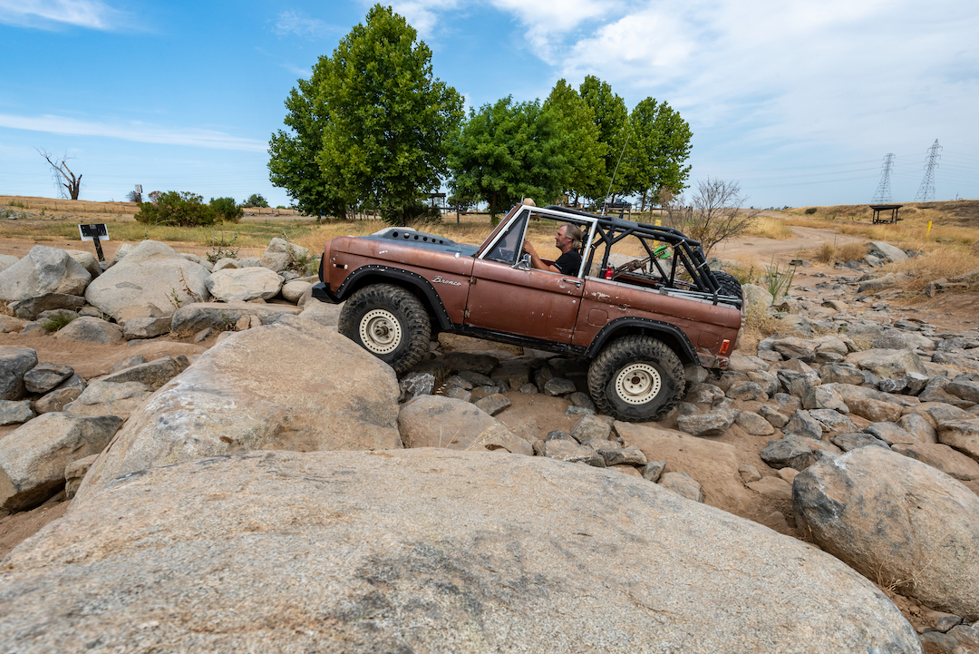
The purpose of the Road and Trail Management Plan (RTMP) is to provide specific guidance and direction for implementing the goals and guidelines of the 2016 Prairie City SVRA General Plan. The RTMP is a comprehensive planning document that examines the SVRA’s existing system of roads and provides specific direction for their long-term construction, maintenance, and management. It considers current and potential public use, park operations, and the protection and enhancement of cultural and natural resources to ensure recreational trail opportunities are made available at their fullest potential. Comprehensive trail planning also considers regional recreational opportunities and connectivity and includes extensive public outreach and input into the design of new trails and experiences.
Specifically, this plan will:
The first stage of the planning process is to develop an inventory of the road and trail system in the park, including features, structures, and erosion severity. This information is used to evaluate road and trail conditions and associated impacts on natural and cultural resources.
Project Base Maps
This map set shows Existing Parkwide Routes, Land Cover/Vegetation, Soil Erosion, Easements and Infrastructure, Trail Erosion, Wetlands, and Park Location maps recently developed during the PCSVRA RTMP planning process.
Landscape Features
This map set identifies unstable landscapes, aquatic environments, and other landscape features within Prairie City SVRA.
Road and Trail Structures Problem Severity
This map shows structural road and trail problems within Prairie City SVRA.
Water Resources
The map shows the potential for trail and road features to impact water resources within Prairie City SVRA and the condition of drainage structures along roads and trails.
Sustainability
This map shows the sustainability of roads and trails within Prairie City SVRA and general recommendations for maintenance.
Trails are a key component of off-highway vehicle (OHV) recreation and are critical to fulfilling the mission of California State Parks and the Off-Highway Motor Vehicle Recreation (OHMVR) Program. Roads and trails provide access to most, if not all, motorized recreation opportunities within State Vehicular Recreation Areas (SVRAs). Sound trail management requires implementing a variety of actions, including:
The OHMVR Division is committed to providing the highest quality trails for a diverse group of recreational users by planning and developing trails pursuant to California State Parks Trails Policy:
The Department of Parks and Recreation, through a public planning process, will strive to meet the recreational, educational, and interpretation needs of its diverse trail users by developing trails within state park units consistent with unit classification, general plan directives, cultural and natural resource protection, public safety, accessibility, use compatibility, and other legal and policy mandates. Multi-use trails and trail connectivity with adjacent public trail systems will be considered in the development of trail plans or individual trails (Departmental Policy Notice no. 2005-06).