
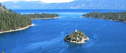
 Name: Emerald Bay State Park
Features: Emerald Bay is world known for its brilliant panorama of mountain-building processes and glacier carved granite. The natural beauty, geology and history of this unique island make it one of the highlights of any visit to the Lake Tahoe area. Fannette Island is located in the Emerald Bay part of California's Lake Tahoe.
Travel: From Sacramento (SMF) Airport 121 miles ~ Drive Time 1 hour, 55 minutes
Website: https://www.parks.ca.gov/?page_id=506
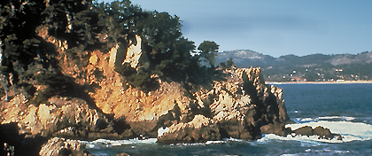 Name: Point Lobos State Reserve
Features: Point Lobos contains headlands, coves and rolling meadows. The offshore area forms one of the richest underwater habitats in the world popular with divers. Wildlife includes seals, sea lions, sea otters and migrating gray whales (from December to May). Thousands of seabirds also make the reserve their home. Hiking trails follow the shoreline and lead to hidden coves.
Travel: From San Jose (SJC) Airport 81 miles ~ Drive Time 1 hour, 29 minutes
Website: https://www.parks.ca.gov/?page_id=571
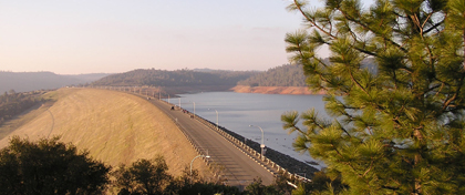 Name: Lake Oroville Recreation Area
Features: Lake Oroville this man-made lake was formed by the tallest earth-filled dam (770 feet above the stream bed of the Feather River) in the country. The lake offers a wide variety of outdoor activities including camping, picnicking, horseback riding, hiking, sail and power boating. The recreation area view has a 47-foot tower, with two high-powered telescopes.
Travel: From Sacramento (SMF) Airport 66 miles ~ Drive Time 1 hour, 36 minutes
Website: https://www.parks.ca.gov/?page_id=462
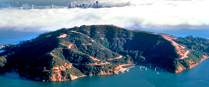 Name: Angel Island State Park
Features: Angel Island is often referred to as the “Jewel of San Francisco Bay” and offers panoramic vistas of the entire Bay. Visitors have picture-postcard views of the Golden Gate Bridge, San Francisco Skyline, Marin, and Mt. Tamalpais. A clear day on the island is referred to as a "5-bridge day" when, from the top of Mt. Livermore, hikers can view the Golden Gate, Bay, Richmond/San Rafael, San Mateo and the Dumbarton bridges. Angel Island is a hilly, grass and forest-covered island and is one mile from the Tiburon Peninsula. The park covers 740 acres and is 788 feet high at the top of Mt. Livermore. Angel Island is rich in historical significance because of the Angel Island Immigration Station.
Travel: From San Francisco (SFO) Airport 31 miles ~ Drive Time 1 hour
Website: https://www.parks.ca.gov/?page_id=468
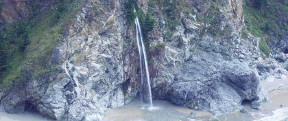
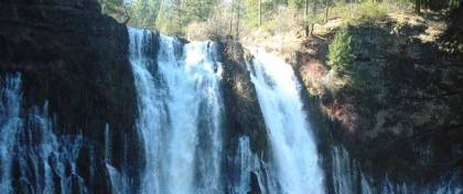 Name: Mc Arthur Burney Falls
Memorial State Park
Features: Teddy Roosevelt once described Burney Falls as the "eighth wonder of the world."
A 1.3 mile trail circles the 129 ft. waterfalls. New campground with many recent renovations, including spur alignments to accommodate larger RV's. There are 121 developed camp sites with no utilities.
Travel: From Sacramento (SMF) Airport 204 miles ~ Drive Time 3 hours, 22 minutes
From Rogue Valley Int'l Airport-Medford, Oregon 151 miles ~ Drive Time 2 hours, 35 minutes
Website: https://www.parks.ca.gov/?page_id=455
 Name: Navarro River Redwoods State Park
Features: Navarro River Redwoods State Park is an eleven-mile-long "Redwood Tunnel to the Sea." The redwood forest along the Navarro River is a magnificent sight. Visitors to this state park can enjoy picnicking, swimming, and the Paul M. Dimmick campground. Second growth redwood groves stretch the length of the park.
Travel: From San Francisco (SFO) 142 miles ~ Drive Time 2 hours, 45 minutes
Website: https://www.parks.ca.gov/?page_id=435
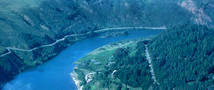
 Name: Millerton Lake Recreational Area
Features: Millerton Lake is nestled in the foothills of the Sierra Nevada, approximately 15 miles east of Fresno, and offers a wide variety of recreational opportunities. Friant Dam on the San Joaquin River, forms Millerton Lake. The dam and lake are features of the Central Valley Project. Numerous camping facilities, ranging from primitive sites to RV hookups are available. The park includes a preserve area for nesting bald eagles, and the park provides boat tours during the winter months for viewing. The lake offers a marina for long term docking as well as day use boat ramps. The historic Millerton Courthouse, once the seat of Fresno County, has been restored and contains interpretive exhibits about the area's local history.
Travel: From Bakersfield (BFL) Meadows Field Airport 134 miles ~ Drive Time 1 hour, 55 minutes
Website: https://www.parks.ca.gov/?page_id=587
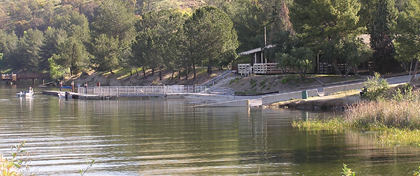 Name: Castaic Lake Recreational Area
Features: Castaic Lake State Recreation Area is a reservoir of the State Water Project. It is one of the Project's largest recreational lakes and the terminal of its west branch. The site includes 29 miles of shoreline. A major attraction is the 425-foot tall Castaic Dam. Castaic Lake has two bodies of water. Lower lake is for non-power boating and canoeing. Upper lake is for sailing, power boating, water and jet skiing.
Travel: From Los Angeles (LAX) Airport 48 miles ~ Drive Time 48 minutes
Website: https://www.parks.ca.gov/?page_id=628
 Name: Julia Pfeiffer Burns State Park
Features: The park stretches from the Big Sur coastline into nearby 3,000-foot ridges. It features redwood, tan oak, madrone, chaparral, and an 80-foot waterfall that drops from granite cliffs into the ocean from the Overlook Trail. A panoramic view of the ocean and miles of rugged coastline is available from the higher elevations along the trails east of Highway 1.
Travel: From San Luis Obispo (SBP) Airport 110 miles ~ Drive Time 2 Hours, 32 minutes
Website: https://www.parks.ca.gov/?page_id=578
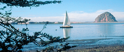 Name: Morro Bay State Park
Features: Morro Bay State Park features a lagoon, natural bay habitat, and the bay’s most prominent landmark is Morro Rock. The park has opportunities for sailing, fishing, hiking, and bird watching. There is a colorful marina and an 18-hole public golf course. On the bay’s northeast edge is a pristine saltwater marsh that supports a thriving bird population.
Travel: From San Luis Obispo (SBP) 17 miles ~ Drive Time 29 minutes
Website: https://www.parks.ca.gov/?page_id=594
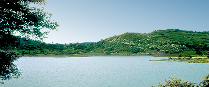
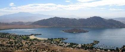 Name: Lake Perris Recreation Area
Features: The Lake Perris State Recreation Area is one of the State’s most popular recreation destinations. The lake is 3 miles long and 2 miles across with about 10 miles of accessible shoreline. The lake elevation is 1,560 feet and the average water temperature is about 70° degrees. Lake Perris is surrounded by mountains which have a vast amount of wildlife to explore.
Travel: From John Wayne Airport (SNA) Santa Ana 74 miles ~ Drive Time 1 hour, 20 minutes
Website: https://www.parks.ca.gov/?page_id=651
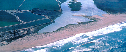 Name: Salinas River State Beach
Features: This State Beach is located one mile south of Moss Landing and features fishing, bird watching, horseback riding and includes scenic beauty as one of Monterey Bay's most interesting sand dune areas. South of this beach is the Salinas River National Wildlife Refuge, home to least terns, brown pelicans and endangered snowy plovers. It is located between Monterey and Santa Cruz,
Travel: From San Jose (SJC) Airport 57 miles ~ Drive Time 1 hour, 15 minutes
Website: https://www.parks.ca.gov/?page_id=573
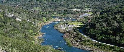 Name: Auburn State Recreation Area
Features: Auburn SRA has over 100 miles of hiking and horse trails that wind through the steep river canyons along the North and Middle Forks of the American River. The most famous trail is the Western States Trail, which runs 100 miles from Lake Tahoe to Auburn, with over 20 miles in the state recreation area. Whitewater recreation has Class II, III and IV runs. Located in the Auburn SRA is the Foresthill Bridge, the 3rd highest bridge in the US and is the tallest in California, some 730+ feet
above the American River.
Travel: From Sacramento (SMF) Airport 41 miles ~ Drive Time 47 minutes
Website: https://www.parks.ca.gov/?page_id=502