
Effects of Off-Highway Vehicles on Archaeological Sites in Red Rock Canyon
The Effects of Off-Highway Vehicles on Archaeological Sites and
Selected Natural Resources of Red Rock Canyon State Park
Michael P. Sampson,
Associate State Archaeologist (Retired)
California State Parks
June 2007
An investigation of off-highway vehicle effects with a focus upon archaeological sites and historical properties within Red Rock Canyon State Park was conducted in 2004-2006. Thirty-six archaeological sites, as well as, sensitive plant and animal habitat and geologic features, are known to be traversed by roads and informal vehicle trails. Damage related to vehicle use consists of the following: long-lasting vehicle scars upon the land, loss of soils and vegetation, gullying, deflation of cultural deposits, displacement and damage to artifacts and geologic features, and others. Soil deflation along roads and the volume of soil loss were found to be significant at certain locations. Solutions to the vehicle-caused problems include the following: installation of effective vehicle barriers, closure of certain routes or route segments, public education, increased patrol by park rangers, regular maintenance of routes of travel, application of erosion-control measures, restoration of damaged terrain, regular monitoring, and others.
Red Rock Canyon State Park (SP) faces a number of complex issues, one of which is the management of off-highway vehicle (OHV) use. This current project was initiated (1) to investigate the state of knowledge on the effects of off-highway vehicles on public lands, (2) to investigate off-highway vehicle use and their effects upon cultural resources and natural values within Red Rock Canyon SP, and (3) to identify some practical measures to address problems associated with off-highway vehicle use. This discussion will outline portions of the fieldwork results and provides recommendations on how to manage vehicular recreation in Red Rock Canyon SP that are potentially applicable elsewhere. [Specific references to archaeological sites and their locations have been removed from this paper to protect them. Such data are confidential by law.]
PROJECT SETTING
Red Rock Canyon State Park, a park unit renowned for its striking scenic qualities, is located in the Mojave Desert portion of Kern County and lies approximately 25 miles north of Mojave. The park occupies the western end of the El Paso Mountains. The focus of the current investigations is a 20,500-acre parcel in the northern end of the park that includes a portion of the Last Chance Canyon Archaeological District and a Birds of Prey Closure zone (Figure 1, above). Red Rock Canyon State Park, located in the western Mojave Desert, is characterized by a diversity of desert floral communities and landform features and contains six natural wildlife habitat types, including, a biologically critical riparian zone in Last Chance Canyon and within Red Rock Wash (California State Parks 2003:2-9-2-26).
Red Rock Canyon SP is home to a number of sensitive animal and plant species, such as, desert tortoise (Gopherus agassizi), Mohave ground squirrel (Spermophilus mojavensis), Golden Eagle (Aquila chrysaetos), prairie falcon (Falco mexicanus), Townsend’s big-eared bat (Corynorhinus [Plecotus] townsendii), Spotted bat (Euderma maculatum), Red Rock tarplant (Deinandra arida), Red Rock poppy (Eschscholzia minutiflora ssp. Twisselmannii), Charlotte’s phacelia (Phacelia nashiana), Mohave fish-hook cactus (Sclerocactus polyancistrus), creosote clone rings, various unique terrestrial invertebrates, and many others. Some of these species are endemic to the park. Habitat for these plant and animal species occur along the main routes of travel in Red Rock Canyon SP.
Large areas of the park along roads and OHV trails are characterized by Holocene-age dunes consisting of loosely compacted aeolian sands that are stabilized by vegetative cover. Desert pavements surfaces occur on terraces at certain locations in the park. The complex geology of the park has provided rocks and minerals of economic value to humans for thousands of years, such as, tool-quality cherts and chalcedonies, placer gold, pumice [volcanic ash], and clays (Dibblee and Gay 1952:30-34; Faull 1990, 2000; Flenniken 2000; Sampson 2003; Troxel and Morton 1962:77, 261-265). Fossil deposits with diverse floral and faunal remains occur throughout the park. In fact, Red Rock Canyon SP has the most complete fossil record for terrestrial animal life of the middle Miocene Epoch known anywhere in North America (California State Parks 2003:2-10-2-11).
Red Rock Canyon SP is located within the traditional range of the Nïwï or Kawaiisu people (Zigmond 1986:398, Fig. 1, Fig. 6). The Kawaiisu language represents the westernmost branch of the Southern Numic division of languages. Numic languages are the most northerly branch of the Uto-Aztecan language family (Miller 1986:98-99, Fig. 1). Refer to narratives by Kroeber (1925:601-603), Merriam (1967:444-446), and Zigmond (1986) for additional information about their culture. Elders and leaders of the local Indian communities met with State Parks staff, including, the present writer, in April 2003 and March 2005 to voice their opinions about vehicular recreation and other important management issues in Red Rock Canyon SP. Mr. Harold Williams, Chairman of the Kern Valley Indian Community, and Mr. Luther Girado, a Kawaiisu Elder, were consulted specifically for this project and shown selected archaeological sites and vehicle trails.
Red Rock Canyon became an important travel route for shipments of provisions for regional mining districts by 1862, and later for passengers (Faull 2000:261, 2003). A short period of historic activity began in Red Rock Canyon and Last Chance Canyon in 1893 during a “rush” to mine placer gold, with the ubiquitous use of dry washers (Faull 1990; Sampson and Faull 1994). The Great Depression of the 1930s stimulated renewed mining activity within present-day Red Rock Canyon State Park, including, Last Chance Canyon and Scenic Canyon (California State Parks 2003:72-73; Faull 1990:132). The miners seeking fortune at this time tended to set-up longer term residency here than that noted in the 1890s, and in some cases, families lived along side them. Industrial mining took place within the park during the twentieth century (Troxel and Morton 1962:261-265).
PREVIOUS ARCHAEOLOGICAL RESEARCH
Archaeological studies of Red Rock Canyon SP began in the early 1960s with surveys by archaeologist Alex Apostolides and continue since State Parks gained ownership (e.g., Sampson 1990, 2003; Sampson and Faull 1994). Most roads and trails within the park have been explored by State Parks Archaeologists and State Parks biologists during fieldwork conducted from 1986 up to the present time (California State Parks 2003; Harvey and Gardner 2003; Sampson 2003; Sampson and Faull 1994).
Documentary research proved useful for assessing the cultural significance of historic-period sites in the park, including State Mineralogist Reports, State Parks files, accounts in popular magazines such as, Desert Magazine and Touring Topics, County reports, and other information. Oral history accounts and anecdotes also provided good first-hand information on some of the historic-period sites.
Red Rock Canyon SP contains a total of 147 recorded archaeological sites and 52 isolated finds, primarily, prehistoric in age [that is, prior to the Spanish arrival in California]. At least a third of this site total can be associated with the prehistoric procurement and knapping of flaked-stone artifacts. Ten sites are defined as aboriginal toolstone quarries (Flenniken 2000; Sampson 2003). Several show good evidence of prehistoric occupation such as, a variety of artifacts, some subsistence remains, roasting pits, etc. Aboriginal rock art was identified at six archaeological sites, including, pictographs, petroglyphs, and a ground figure (Sampson 1990, 2003). Chronological data obtained during archaeological excavations (e.g., Gardner 1998:128-140; Harvey and Gardner 2003:54-59; McGuire et al. 1982:75-76, 94) and State Parks surveys suggest that prehistoric use of the park occurred in most time periods, but more frequently during the Gypsum Period (4000-1500 years before present) and the Rose Spring Period (1500-1000 years before present). Historic sites primarily date to the late 1890s and early decades of the twentieth century (Dibblee and Gay 1952; Faull 1990; Sampson and Faull 1994; Troxel and Morton 1962:261-265).
RESEARCH ON OFF-HIGHWAY VEHICLE EFFECTS
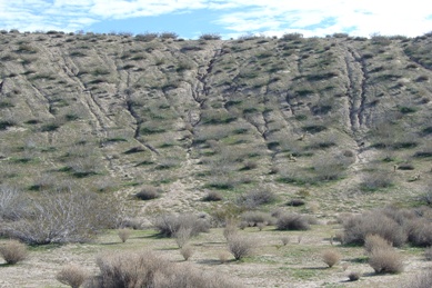
A large volume of published research exists concerning the effects of off-highway vehicle use upon public lands, including, numerous studies in the California deserts (e.g., Belnap 1995, 2002; Brattstrom and Bondello 1983; Bury and Luckenbach 1983; Eckert et al. 1976; Gilbertson 1983; Havlick 2002; Hinckley et al. 1983; Kassar 2005; Lathrop 1983; Lovich and Bainbridge 1999:315-322; Lyneis et al. 1980; Shore 2001; Sowl and Poetter 2004; Webb and Wilshire 1983; Wilshire 1977, 1983; and others). Scientific research on OHV effects initially grew out of a response by federal and state land-managing agencies to the exploding growth of vehicle recreation in the late 1960s and through the 1970s. According to this research, off-highway vehicles damage soils directly through (1) disruption of the surface soil and (2) compaction of the surface soil and subsoil (e.g., Belnap 1995, 2002; Dregne 1983:26; Webb et al. 1978:228-232). The most important long term effect of OHV use on public lands is the accelerated erosion and the attendant inability to support natural revegetation (Webb et al. 1978:219). Dr. Howard Wilshire (1977, 1983), then a geologist with the US Geological Survey, states that none of the natural soil stabilizers inherent to California deserts can hold up to the damaging effects of repeated vehicle passes. Even a single pass by an OHV or any vehicle upon desert soils can be sufficient to effectively destroy soil components (Wilshire 1977:ii). Tuttle Ridge, a landform found in Red Rock Canyon SP, is a prime example of extraordinary soil and plant loss from OHV use (see the observations in Wilshire 1977:6-8). Soil and sediment loss in the areas disturbed by vehicles was determined to be 11 million kg of material (Wilshire and Nakata 1977). Ongoing gully erosion and highly visible scarring on Tuttle Ridge over 25 years after its closure to vehicle use are manifestations of past unregulated OHV recreation (Figure 2, pictured below).
Off-highway vehicle use produces a damaging effect upon vegetation, and plant rehabilitation efforts often are marginally successful or unsuccessful (e.g., Havlick 2002:96-98; Kutiel et al. 200:19-20; Lovich and Bainbridge 1999:316, 320-321; and others). An investigation of plant cover loss at OHV use-areas has been found to range from 23% at the location of a one-time OHV event to upwards of 91% and 96% in areas of concentrated vehicle use (Lathrop 1983:157-163). Various studies point out that even a single pass by a four-wheel drive vehicle will reduce plant density and outright destroy small-sized plants (Lathrop and Rowlands 1983:144-146; Kockelman 1983:416-417).
When the soil is wet, the destruction caused by the passing of a single vehicle track is more pronounced, due to increased soil compaction. Natural recovery of soils and vegetation, that is, without active, sustained restoration efforts, in OHV-affected areas is neither practical nor effective and the resultant plant community may not resemble the predisturbance one (Lovich 1999; Prose and Wilshire 2000:18-19; Webb et al. 1983:297-300). Disturbance from vehicular activities in arid lands will take long periods of time to naturally recover, even decades or centuries (Elvidge and Iverson 1983; Lovich 1999; Webb et al. 1983:297).
OHV use affects wildlife directly by producing the loss of plant cover, loss of potential food sources, potential damage to burrows, excessive noise, driving across migration and forging routes, frightening animals enough to abandon their habitats, hearing loss to animals, and death (Brattstrom and Bondello 1983;Bury and Luckenbach 2002; California Department of Parks and Recreation 1978:26; Havlick 2002:36-58, 96-99; Jennings 1997; Kassar 2005:15-37; Nicolai and Lovich 2000; Shore 2001:Table 3.15; Sowl and Proetter 2004:9-11). The removal of vehicles from an area regularly used by OHVs can result in measurable improvements in vegetation growth and greatly increased wildlife numbers. For example, a long-term study in Coyote Canyon located within Anza-Borrego Desert SP has demonstrated this positive effect (Ostermann and Boyce 2002).
Off-highway vehicle damage was identified as a significant source of damage to archaeological sites and other historic properties, second only to development, in a 1979 Bureau of Land Management (BLM) study (Lyneis et al. 1980). The study found that OHVs enabled artifact collectors and pothunters to drive out to vast areas of public land, some of which was formerly difficult to access. Vehicles can also facilitate the inadvertent or purposeful destruction of significant cultural features [such as, the famous case of the OHV damage to the Yuha Desert ground figures near Blythe]. Vehicle-caused damage to archaeological sites occurred most frequently in accessible areas close to roads and campgrounds according to the 1979 study. One recommended site protection strategy was moving roads away from archaeological sites to make them more inaccessible (Lyneis et al. 1980:146-147).
Other studies have found that archaeological sites can potentially be subjected to vehicular impacts similar to those identified in the 1979 BLM study. For example, cultural features and artifacts lying on the surface will be appreciably altered and/ or broken due to routine road use and unauthorized off-trail vehicle incursions, according to the results of State Parks studies (e.g., Schneider 2005) and ones in other states. A study of recreation effects to archaeological sites in Colorado found OHV activity to be a significant source of damage to many sites (Hartley and Vawser 2004:3-5). A study in Utah and Arizona and in Alaska found that OHV use causes inadvertent damage to sites to public lands, while also making remote sites more accessible to site vandals (Schiffman 2005; Sowl and Poetter 2004:11-12).
METHODS
Fieldwork for the current project was accomplished primarily by the author during field trips in 2004 through spring 2006. At times, Larrynn Carver, Mark Faull, Phil Hines, Chris Peregrin, and Kyle Knabb assisted with fieldwork. Bruce Lund and Phil Hines, from the State Parks Off-Highway Motor Vehicle Recreation Division, discussed issues related to OHV use with the author and met in the field on June 22, 2006 to examine selected vehicular trails and discuss potential erosion-control measures (cf. California Department of Parks and Recreation 1991). Michael Sampson toured Hungry Valley State Vehicular Recreation Area on April 28, 2005 to view visitor management techniques used at an OHV recreation park. Pete Yarbrough and Kim Matthews from Hungry Valley District and Dr. Howard Wilshire, retired US Geological Survey geologist and vehicle effects expert, toured the project area with the present writer on October 12, 2005.
In terms of locations within Red Rock Canyon SP, much of the fieldwork time was spent within the northern end of the park, including, Last Chance Canyon, Iron Canyon, Nightmare Gulch, Red Buttes, as well as, selected portions of the more southerly areas of the park. The principal routes of travel in the latter areas were photographed during the fieldwork to document their current condition as baseline data for future evaluation work. Vehicle tracks driven off-trail, a use not permitted by park regulation, were documented by photographs and GPS point when observed in travels throughout the project area. Width and depth of cut measurements were taken along the routes of travel where they traversed archaeological sites, as well as, observations of exposed artifacts or cultural features.
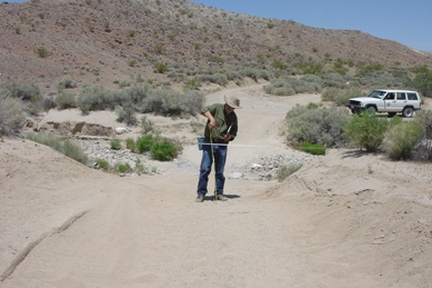
Measurements of road deflation (present road depth relative to the unaffected surface) and soil loss within roads were accomplished at selected archaeological sites in the project area. Measurement of road deflation within sites involved use an automatic level instrument set-up upon unaffected ground surface with multiple shots taken within a roadway and on ground outside the road. Thus, the difference in depth between the road surface and unaffected ground surfaces could be captured to provide a measure of the road-cut depth.
Soil loss within a road where it passes through an archaeological site was measured, as means to document the amount of erosion caused by vehicle traffic. From an arbitrary starting point on-site, a series of spikes were layed out at 10-foot intervals on opposite sides of the roadway on unaffected ground (Figure 3). A long tape measure was extended between the two spikes and depth measures were taken at one-foot intervals within the roadway. A profile of the road surface is thus produced, and measurements of soil loss can be calculated using the recorded figures. This technique for measuring soil loss is outlined in an article by Dr. Howard Wilshire (2000), a retired US Geological Survey geologist. The amount of soil compaction within a single OHV track was also measured at a few selected locations; here, the depth and width of the track was measured from existing ground surface. Erosional gullies of appreciable size found within roads at archaeological sites were photographed, measured, plotted with a GPS receiver, and placed on park maps.
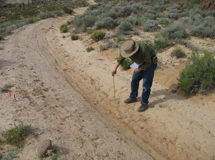
Figure 3. A long tape measure was extended between the two spikes and depth measures
were taken at one-foot intervals within the roadway. A profile of the road surface is thus
produced, and measurements of soil loss can be calculated using the recorded figures.
OHV EFFECTS AT RED ROCK CANYON SP
A total of 36 archaeological sites within Red Rock Canyon SP are known to be traversed by park roads or informal OHV trails. Thirteen of these archaeological sites are defined as prehistoric occupation locations, each with substantial surface artifact distributions and subsurface cultural deposits. Another eleven sites are defined as prehistoric lithic scatters; they tend to be large in size. Seven of the 36 sites crossed by roads or OHV trails are historic-period mining related work camps; two of the work camp sites also have mining features. Four prehistoric stone quarry sites within Red Rock Canyon SP have roads running through them. One historic stage station site is regularly crossed by OHV traffic.
Each of the 36 archaeological sites is experiencing at least some degree of degradation due to vehicle use and consequent erosion within the trail tread, and 17 of the 36 sites show pronounced damage. Damage related to vehicle use observed at archaeological sites in Red Rock Canyon SP include the following: deflation of the cultural deposits within the trail treads, degradation of cultural deposits (midden), vehicle scars resulting from off-trail riding, loss of soils and vegetation, gullying, displacement of artifacts, damage to artifacts and cultural features, road damage requiring extensive and potentially costly restoration efforts, alteration of natural hydrologic patterns, trash left on-site, unauthorized artifact collection, and possibly others. Off-trail riding, an activity not permitted within Red Rock Canyon SP, is a regularly occurring problem at 13 of the archaeological sites (36%) crossed by roads and OHV trails. Unregulated camping, an activity that results in ground fires, plant destruction, significant soil movement, and trash accumulations, has been an indirect adverse effect of OHV use in the park but is now prohibited.
Site-specific findings and management recommendations are now summarized for a sample of the project locations visited for this study. Those selected are a good representation of observed OHV effects and proposed treatments.
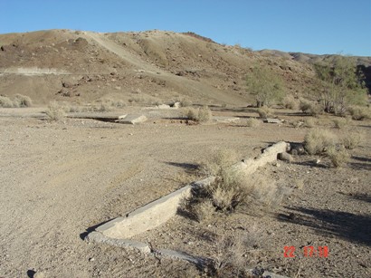
Parallel trail segments were observed and documented on Sierra View Road near Old Dutch Cleanser Mine Road. Subsequently, the most downcut trail segment (Figure 4, pictured below) was closed to vehicular use with carsonite signs and placement of rocks across either end. Motorcycle riders have begun to cut across the vegetation island separating the two trail segments; these new unauthorized trails have now been blocked with rows of rocks.
An ideal solution will include the installation of peeler log barriers or large boulders on either end of the closed vehicle trail segment, and then attempt revegetation. Revegetation must incorporate locally collected seeds; the seed mix could be hydroseeded onto the abandoned vehicle trail. To make restoration successful here, State Parks may have to import soils and repair the existing soil system within the abandoned trail segment, inoculate the soils with mycorrhizal fungi prior to restoration, and consider transplanting seedlings rather direct seeding (cf. Lathrop and Rowlands 1983:138-146; Lovich 1992:35-42).
The closed, eroded OHV route is now acting as a “natural hydrologic feature,” and channels water and loose sediment directly onto Old Dutch Cleanser Mine Road thus creating a storm management problem at this location. One possible solution will be to build a drain channel heading off to the west from Old Dutch Cleanser Mine Road to carry water off the road. Placement of erosion-control devices at intervals of every 100 to 150 meters would slow water velocity upon Old Dutch Cleanser Mine Road and any attendant erosion.
Steep Trail crosses sensitive resource locations for approximately 500 ft or ca. 152 m in a northeasterly direction. The downcutting effect of continued vehicular use upon the terrain with its loose, sandy soils is considerable and readily apparent. At the junction of the latter two roads, Steep Trail has two paths that converge just less than 55 feet or 16.7 meters below Old Dutch Cleanser Mine Road. One vehicle route measured 14 feet or 4.3 meters in width; the other measures 19.5 feet or 4.7 meters in width. A measure of deflation here showed Steep Trail measured 2.76 feet or 0.87 meter lower than unaffected terrain. This vehicle-caused deflation creates a significant loss of soils.
An informal, unauthorized motorcycle trail leads off from Steep Trail just below Old Dutch Cleanser Mine Road. A deflation measurement taken within the informal trail indicates it lies 0.91 foot or 28 centimeters below the unaffected terrain on the road edge. The informal OHV trail measures 8.5 feet or 2.6 meters in width.
The unauthorized OHV trail mentioned above was blocked with bales of rice straw, a row of rocks, and carsonite sign in spring 2006, but needs a more permanent barrier, such as, a few large boulders, is needed here. The other end of this unauthorized trail located near Sierra View Road, should be relocated and blocked. The installation of water management features on the closed unauthorized trail is also recommended. The portions of the unauthorized trail lacking plant cover probably should be scarified using a hand crew to help promote seed growth.
Severe erosion has occurred on the east edge of the upper end of Steep Trail, at a spot about 590 feet north of Old Dutch Cleanser Mine Road. Steep Trail is sloped here, so, these conditions can produce too much water and too much water velocity and combine to be problems for soil and trail stability. Boulders should be placed within the erosional gully located just to the southeast of Steep Trail and boulders situated along the edge of Steep Trail. Nearby, an erosion-control device should be installed on Steep Trail at a place about 200 feet north of (down slope from) Old Dutch Cleanser Mine Road.
A prominent hill located on the boundary between BLM land and State Parks land overlooks Last Chance Canyon and the now-closed Steep Trail. On BLM land, the site falls within a designated Area of Critical Environmental Concern. The hill is scarred by parallel informal OHV trails. The OHV trails on the south slope and top of the hill represent highly visible scars upon this prominent hill. The parallel and redundant OHV trails on the south and west slopes of the hill should be eliminated and restored. Any vehicular route kept open for use on-site should be well delineated with rocks and signs.
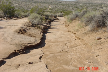
Figure 4. New downcutting on OHV trail after rains.
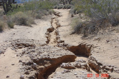
Figure 5. Erosion channels deeply cut into OHV Trail.
Erosion within the OHV trails is most pronounced at the base of the hill. Some park visitors are attracted to this hill for rockhounding yet it lacks a park sign indicating that rock collecting is prohibited here. [Note: Rock collecting is prohibited by State law in all areas of the park.] The present writer, too, has observed motorcyclists driving upslope at a fast pace onto the site using the OHV trails; driving at high throttle upslope tends to displace greater amounts of soil and rock. The resultant vehicle trails on the steep slopes are highly susceptible to the erosive forces of rain, wind, and continued use by OHVs (see, for example, Hinckley et al. 1983:86-89, 92-94; Iverson et al. 1981; Wilshire 1977.). Presently, this hill has no signs stating the State Parks rules nor have any measures been implemented to block the poorly designed informal OHV trails.
Heavy rains have caused extraordinary erosional damage within Steep Trail, an OHV route closed to vehicle use since March 2006. Large gullies or channels are deeply cut into the trail tread (Figure 5, pictured above). Measurements of erosional channels cut into Steep Trail were taken at selected places and shows widths and depths up to 35 inches (89 cm) wide and 20 inches (51 cm) in depth. The depth of Steep Trail below the undisturbed ground surface where no gullying occurred is .82 feet (25 cm). Depth measurements taken with the automatic level at two locations within the erosion gullies here were 4.64 feet (1.42 m) and 2.37 feet (73 cm). These indicate a significant loss of sediments from the site. Artifacts and cultural features were exposed in places, soils displaced, and plants damaged within the erosion areas. Desert tortoises, a State and Federal Threatened species, have been observed along the now-closed areas of Steep Trail.
OHV tracks leaving the trail, principally, motorcycles, and heading off onto unaffected terrain have been a recurring problem until Steep Trail was closed by Superintendent’s order in March 2006. During routine visits prior to its closure, motorcycle tracks have been mapped leaving Steep Trail and driving onto the site from 10 ft to 40 ft out. Cultural deposits were displaced in places and shrubs damaged.
The lower end of Steep Trail shows severe erosional damage. Deep gullies are cut into the trail tread, in many places down to bedrock or to point where large boulders appear out of the trail tread (e.g., at the lowest end of the trail just above the canyon bottom). Gullies showed measurements ranging from 18 inches (46 cm) deep and 30 inches (75 cm) wide to 48 inches (1.2 m) deep and 44 inches (1.12 m) wide.
Soil loss was calculated in April 2006 for a 120-foot-long segment of Steep Trail as its passes through an archaeological site. The volume of soil loss in this segment of the OHV trail measured 2,674 cubic feet of soil, a significant amount. Therefore, the total volume of soil lost to erosion along Steep Trail down to the bottom of Last Chance Canyon may be as much as 64,845 cubic feet. The latter figure is reached by extrapolating the volume of soil lost within the site to the known length of severe erosion on this section of Steep Trail, to the bottom of Last Chance Canyon (2,910 feet).
The section of Steep Trail just below the upper closure point (the trail runs roughly east-west here) needs water-management devices to divert water off-trail. One means to stop the channeling of water upon Steep Trail here would be to knock down the berms along the down slope or south side of the abandoned trail. A light gray caliche is exposed along here within the road bed. Caliche forms a bedrock-like layer that can be relatively thick and may even be laminated (H. Wilshire, personal communication, 2005).
Park signs should be placed on access points stating the State Parks rules. Most OHV trails leading onto the now-closed road section should be closed, and some level of restoration must be attempted to slow erosion and to “soften” the harsh appearance of the trail scars.
Active management measures should be applied areas along Steep Trail to protect archaeological sites from further degradation, preserve soils, and protect animal and plant habitats. Vehicles must be kept off Steep Trail, interim erosion-control measures implemented, and then plan and implement restoration work for Steep Trail and any off-trail OHV tracks. Some limited archaeological data-recovery work will be necessary where restoration work requires excavation or placement of erosion-control devices into the ground, if archaeological sites are present.
Steep Trail takes a steep drop down the slope to the bottom of Last Chance Canyon. The current ongoing pronounced erosion on this abandoned section of Steep Trail can be arrested with a control of water volume and velocity within the trail tread. The source of water at the top of the slope must be broken, and then work down the slope. Excavate breaks in the road shoulder berm on the east side of Steep Trail measuring about 3 to 4 feet in width at intervals of about every 100 feet to 150 feet. These breaks will serve as a useful interim erosion-control measure by pulling water off the abandoned and eroding trail tread. Sediments forming the berm breaks should be pulled onto the tread of the abandoned trail.
The terrain lessens in degree of slope lower down the closed trail and has a deeper sandy sediment content, including, where sensitive resources occur. Here, grade control is needed within the deep gullies. Establish check dams within the gully bottoms using massive amounts of local rock at intervals of around 100 feet to 200 feet. Build the check dams at an angle. Build the dam up to present grade at every third check dam. Where gullying has not occurred on Steep Trail, erosion-control devices and rock dams could be constructed on the surface of the trail to direct water off to one side or the other, along with breaks in the east side berms.
The entire length of Steep Trail and adjacent terrain should be surveyed for desert tortoise, Mojave ground squirrel, and sensitive plant species. Any restoration proposals for the closed trail must take into consideration the need to enhance plant and wildlife habitats. Interim erosion-control work or more permanent restoration work will require with strict biological monitoring procedures and archaeological monitoring.
The existing main vehicular trail through Last Chance Canyon traverses the canyon bottom and passes through prehistoric sites in places. The vehicle route lies within a riparian zone in certain locations. Soil loss transects were established and measured along the existing OHV route that now traverses one of those archaeological sites on May 10, 2006.
The loss of soils at this location was found to be significant; the OHV trail measured up to 35½ inches (90 cm) deeper than the undisturbed portion of the site (Figure 6, pictured above). The volume of soil lost within the 55-foot-long transect within this site was determined to be 481 cubic feet. The loss of soil extrapolated along the entire length of the OHV trail where it passes through the site (246 feet) calculates to 2,151.38 cubic feet. That figure represents a significant amount of soils and cultural deposits lost to vehicle use. In addition, vehicles do drive off-trail along this section of the OHV route.
Next to and below “Grubstake Hill,” the riparian zone in the canyon bottom of the middle of Last Chance Canyon is designated by park signs as closed to vehicles. Water, being present at this location year-round, is critical to the resident and migratory wildlife. OHV tracks were observed within this closed section on every occasion when SSC staff visited this location during the current project. OHV users tend not to stop to read regulatory signs, as suggested by a 1994 park study (Faull 1994). Park staff has proposed new fencing at this location to better protect the riparian zone.
The site of Cudahy Camp has been impacted by modern-day camping and vehicle activity. Illegal target shooting would occur at this location and considerable trash has been left on-site by campers. The campers damage the remains of the historic buildings and displace surface artifacts. The site has now been closed to camping. OHV users perform unauthorized hill climbs on the edge of the residential area that leave the bare slopes scarred and highly susceptible to erosion (Figure 7, pictured below).
Our knowledge of the archaeological resources within the middle portion of Last Chance Canyon, as well as, the sensitive natural values and geologic features, points to vehicle closure as a good alternative for optimum site protection and preservation of the riparian zone. The existing vehicular route and any possible riparian bypass route through here may potentially traverse multiple significant archaeological sites and sensitive plant and wildlife habitat, and potentially affect geologic features. A closure of a relatively short section of middle Last Chance Canyon would still allow vehicle access to this part of the park. Park visitors in vehicles could drive south through the upper portion of Last Chance Canyon, access the canyon from the south off of Redrock-Randsburg Road, or, access the middle of the canyon via Pleasant Valley Road. Detailed biological surveys should be conducted within Last Chance Canyon to update previous observations there.
Highly visible scars from uncontrolled OHV use, in particular, hill climbs, that occurred prior to State Parks purchase can be seen while driving through Iron Canyon. Some restoration work was attempted on a vehicle-scarred hill just south of Scenic Cliffs, where a scene from the movie “Jurassic Park” was shot, but, the restoration work has been largely unsuccessful. The lack of plant growth on this hill may be attributed to a number of factors, including, no use of mycorrhizal fungi, poor rainfall immediately following the restoration work, area was not closed to the public, and not enough monitoring of the revegetation plots. The lesson to present-day park managers: OHV tracks are highly visible on the landscape, long-lasting, and difficult to restore.
The archaeological sites, where they are traversed by roads and vehicle trails, should be revisited regularly to update their condition and monitor vehicle-use patterns. The most pronounced soil loss and degradation of cultural remains due to erosion will be found at these locations. Some limited archaeological data-recovery work may be needed at specific sites to address the ongoing erosion problem. Movie production work proposals should be discouraged on certain roads in the park, due to the large number of large trucks and other vehicles required for such work. The heavy equipment and frequent vehicle trips associated with film production accelerate the degradation of the important historic sites that are now traversed by vehicle routes. Fences placed along roadsides at sensitive locations such as, riparian zones and rare animal and plant habitat, should be kept in good repair.
GENERAL RECOMMENDATIONS FOR RED ROCK CANYON SP
- Provide a map of Red Rock Canyon SP to the public that clearly illustrates roads and trails and lists park rules and regulations.
- Permit OHV use only upon roads and trails where the least amount of resource damage will occur. Selection of such areas should include consideration of topography, soil characteristics, precipitation patterns, presence of sensitive resources such as, archaeological sites, traditional cultural places, plants, wildlife habitat, fossil deposits, riparian zones, etc.
- Apply standard engineering practices in the construction and maintenance of vehicular trails. Devise means to contain the increased runoff and sediment loads associated with vehicle use. Assure that routes used by vehicles in Red Rock Canyon SP have adequate trail drainage features.
- OHV trails should not be permitted within creeks or other riparian areas. Vehicle use can compromise or destroy riparian areas and the vegetation along a riparian corridor.
- Implement an active program of archaeological, biological, and geologic monitoring in the park and include a provision to study vehicle effects.
- Vehicles should be restricted from dune systems, due to their loose soils and to best protect sensitive plants and animals that live in dune habitats (e.g., desert tortoise, etc.).
- Separate OHV use from other recreational pursuits, such as, camping, bird watching, observing wildlife, studying plants, seeking solitude, taking photographs, etc., where feasible. OHV use is incompatible with Indian people conducting ceremonies.
- Evidence of off-trail riding by OHV users has been observed on vehicle routes in many areas of the park. When an unauthorized vehicle track is found, it must be raked-out and blocked as soon as possible to prevent continued use. Park staff could regularly patrol travel routes after busy weekends and holidays to maintain areas and block unauthorized trails. Place Carsonite signs with a “Closed to Vehicles” sticker at periodic intervals along popular routes of vehicle travel.
- The closure of vehicle routes does not equate to land restoration. Interim erosion-control measures, a plan for restoration, and (ideally) a funding source should be identified at the time routes are closed. Inventory and map them throughout Red Rock Canyon SP, apply road barriers and interim erosion-control devices, prepare a plan to restore the abandoned trails, and implement the restoration plans.
- Large boulders, fencing, and road obliteration will be the most effective barriers for closing roads and informal OHV trails and to protect sensitive habitat or archaeological sites. Peeler log fences, for example, have been found to be effective barriers.
- Regularly patrol the backcountry portion of Red Rock Canyon SP. Conduct focused examinations of vehicular trails after traditionally busy weekends, such as, Thanksgiving, Christmas break, President’s weekend, spring time with moderate temperatures, etc. Be prepared to perform ad hoc repairs of vehicle tracks driven off-trail and blockage of unauthorized trails.
CONCLUSIONS
There are 35 years of scientific research that detail the serious adverse effects of off-highway vehicles upon desert soils, wildlife, vegetation, archaeological sites, spiritual values, scenery, solitude, passive recreation, and other values. Arid lands simply cannot sustain vehicular recreation for an appreciable period of time, in particular, when it is loosely regulated and not well maintained. Off-highway vehicles and customized street-legal vehicles provide access to previously remote locations where extant archaeological sites and natural resources cannot be regularly patrolled, studied, monitored, or maintained.
Vehicular recreation is recognized as a significant and challenging park management issue for Red Rock Canyon State Park. A total of thirty-six archaeological sites are directly traversed by roads and informal OHV trails within Red Rock Canyon SP. Seventeen of the 36 archaeological sites (46%) manifest pronounced damage resulting from regular OHV use and erosion that follows from vehicular activity. Critical habitat occurs along these same routes of travel.
The damage defined here as “pronounced” includes, measurable deflation of the sites within road beds or the trail treads, degradation of cultural deposits, vehicle scars resulting from off-trail riding, road damage requiring extensive and costly restoration efforts, loss of soils in measurable volumes, loss of vegetation, creation of deep gullies, displacement and damage to artifacts and cultural features, modern-day trash left on-site, alteration of natural hydrologic patterns, and other problems (Figure 8, pictured below). Off-trail riding by OHVs was found to be a recurring problem at specific locations within the park (Figure 9, pictured below), but, the problem can be easily treated using well-situated park signs and vehicle barriers, increased ranger patrol, issuance of more citations, limiting “green sticker” vehicle use to specific routes, and other measures. Some of the archaeological sites investigated for this project are now within areas closed to vehicles. The prohibition of unregulated camping will also help eliminate one of the significant indirect effects of OHV use.
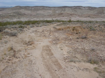
Figure 8. Damage can include, deflation of archaeological sites,
accelerated erosion, long-lasting scars on the land, and many others.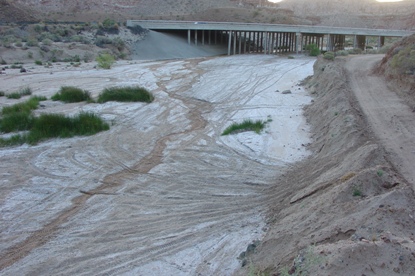
Figure 9. Off-trail riding by OHVs was found to be a recurring problem at specific
locations within the park, but, the problem can be easily treated.
California State Parks could be proactive in fulfilling its mission to protect and preserve its valued resources and provide high-quality recreation at Red Rock Canyon State Park by keeping OHV use areas wholly separate from the hiking, bird-watching, sky-watching, seeking solitude, learning about nature, enjoyment of scenery, conducting ancient California Indian ceremonies, visits by school groups, and by permitting natural ecological processes to occur undisturbed and unimpeded by human intervention. This same recommendation should be applied to public lands nationwide.
On a more general level, California State Parks cultural and natural specialists do try to identify various factors that cause damage or degrade archaeological sites and animal and plant habitats throughout the system and, then, seek solutions. One possible means would be to establish a statewide cultural inventory and monitoring program, and build it into existing programs employed in all park units. The current project at Red Rock Canyon SP might be viewed as an example of an evaluation and monitoring program for vehicular recreation that could be applied at more State Parks and other public lands. Effective, thoughtful resource management will always produce a more enjoyable and memorable recreational experience for the visiting public.
ACKNOWLEDGEMENTS
This project was funded through grants from the Department’s Cultural Stewardship Program, a resource-management initiative created by the 2000 Park Bond. Mark Faull, a friend, colleague, and retired State Park Ranger, provided countless hours of volunteer field time to this project and important data on OHV use-patterns in Red Rock Canyon State Park. Mark generously shared his knowledge of the plants, animals, and geology of the park to the author. Dr. Howard Wilshire, retired USGS geologist and recognized vehicle-effects expert, provided considerable information and volunteered his time to tour the park with the present writer. Kim Matthews, Pete Yarbrough, and Bruce Lund assisted the project with a site tour and technical advice. Phil Hines, my long-time Parks colleague, assisted with three days of fieldwork, ran the Automatic Level instrument for deflation studies, and provided valuable advice on the management of OHV use. I thank Larrynn Carver, Chris Peregrin, and Kyle Knabb for their help with the fieldwork. I also thank my State Parks colleagues at the Southern Service Center, Tehachapi District, and those at Red Rock Canyon State Park, esp., Leo Humphrey.
REFERENCES CITED AND SELECTED BIBLIOGRAPHY
Altschul, Jeffrey H., Carla R. Van West, and Patrice A. Teltser
1998 A Paleoclimatic-Archaeological Model of Prehistoric Settlement in the Mojave Desert.
In Springs and Lakes in a Desert Landscape: Archaeological and Paleoenvironmental Investigations in the
Silurian Valley and Adjacent Areas of Southeastern California, edited by Brian F. Byrd, pp. 79-136.
Report on file, U.S. Army Corps of Engineers, Los Angeles.
Archer, Fred
1925 Southern California’s Petrified Forest. Touring Topics, January.
Basgall, Mark E. and M. C. Hall
1994 Perspectives on the Early Holocene Archaeological Record of the Mojave Desert.
In Kelso Conference Papers, 1987-1992, edited by G. Dicken Everson and Joan Schneider, pp. 63-81.
Occasional Papers in Anthropology No. 4, Museum of Anthropology, California State University, Bakersfield.
Belnap, Jayne
1995 Surface Disturbances: Their Role in Accelerating Desertification.
Environmental Monitoring and Assessment 37:39-57.
2002 Impacts of Off-Road Vehicles on Nitrogen Cycles in Biological Soil Crusts: Resistance in Different U.S. Deserts.
Journal of Arid Environments 52:155-165
Bettinger, R. L. and M. A. Baumhoff
1982 Numic Spread: Great Basin Cultures in Competition. American Antiquity 47: 485-503.
Boarman, William I.
N.D. Desert Tortoise Gopherus agassizii.
Boarman, William I., Marc Sazaki and W. Bryan Jennings
1997 The Effect of Roads, Barrier Fences, and Culverts on Desert Tortoise Populations in California, USA.
In Proceedings: Conservation, Restoration, and Management of Tortoises and
Turtles-An International Conference, pp 54-58. New York Turtle and Tortoise Society.
Brattstrom, Bayard H. and Michael C. bondello
1983 Effects of Off-Road Vehicle Noise on Desert Vertebrates.
In Environmental Effects of Off-Road Vehicles, Impacts and Management in Arid Regions, pp. 167-206,
edited by Robert H. Webb and Howard G. Wilshire. Springer-Verlag, New York.
Bury, R. Bruce and Roger A. Luckenbach
1983 Vehicular Recreation in Arid Land Dunes: Biotic Responses and Management Alternatives.
In Environmental Effects of Off-Road Vehicles, Impacts and Management in Arid Regions, pp. 207-221,
edited by Robert H. Webb and Howard G. Wilshire. Springer-Verlag, New York.
2002 Comparison of Desert Tortoise (Gopherus agassizii) Populations in an
Unused and Off-Road Vehicle Area in the Mojave Desert. Chelonian Conservation and Biology 4(2): 457-463
California Department of Parks and Recreation
1978 Off-Highway Vehicle Recreation in California. California Department of Parks and Recreation, Sacramento.
1991 Soil Conservation Guidelines/Standards for Off-Highway Vehicle Recreation Management.
California Department of Parks and Recreation, Off-Highway Motor Vehicle Recreation Division, Sacramento.
California State Parks
2003 Red Rock Canyon State Park, Preliminary General Plan Amendment & EIR.
California State Parks, Southern Service Center, San Diego. Draft.
Celliers, L., T. Moffett, N.C. James and B.Q. Mann
2004 A Strategic Assessment of Recreational Use Areas for Off-Road
Vehicles in the Coastal Zone of Kwazulu-Natal, South Africa. Ocean and Coastal Management 47(3-4): 123-140
Cloudsley-Thompson, J.L.
1984 Review of Environmental Effects of Off-Road Vehicles: Impacts and Management in Arid Regions,
by Webb, R. H. and Wilshire, H. H. (Eds). The Journal of Ecology 72(3): 1101-1102
Crespin, Bruce M.
1998 Sacred Rocks: Not for Public Consumption.
Proceedings of the Society for California Archaeology, Volume 12:199-211.
D’Azevedo, Warren L.
1986 Introduction. In Handbook of North American Indians, Volume 11: Great
Basin, edited by Warren L. D’Azevedo, pp. 1-14. Smithsonian Institution
Press, Washington, D.C.
Dibblee, T. W. and T.E. Gay, Jr.
1952 Mineral Deposits of the Saltdale Quadrangle, California.
California Division of Mines, Bulletin No. 160. San Francisco.
Dregne, Harold E.
1982 Soil and Soil Formation in Arid Regions. In Environmental Effects of Off-Road Vehicles,
Impacts and Management in Arid Regions, pp. 15-30, edited by Robert H. Webb and
Howard G. Wilshire. Springer-Verlag, New York.
Eckert Jr., R.E., M.K. Wood, W.H. Blackburn, and F.F. Peterson
1976 Impacts of Off-Road Vehicles on Infiltration and Sediment Production of Two Desert Soils.
Journal of Range Management 32(5): 394-397.
Elvidge, Christopher D. and Richard M. Iverson
1983 Regeneration of Desert Pavement and Varnish. In Environmental Effects of Off-Road Vehicles,
Impacts and Management in Arid Regions, pp. 225-243, edited by Robert H. Webb and Howard G. Wilshire.
Springer-Verlag, New York.
Faull, Mark R.
1990 Cultural Resource Management at a Natural History Park: Red Rock Canyon State Park, Kern County, California.
In Death Valley to Deadwood; Kennecott to Cripple Creek, Proceedings of the 1989 Historic Mining Conference,
Death Valley National Monument, pp. 129-136, edited by Leo R. Barker and Ann E. Huston.
1994 Off Highway Vehicle Spring 1994 Data Gathering and Evaluation, Red Rock Canyon State Park.
Manuscript on file, California Department of Parks and Recreation, San Diego.
2000 Recognition of Cultural Significance at Red Rock Canyon, Kern County, California.
Proceedings of the Society for California Archaeology, Volume 13:259-265.
2003
A Historical Overview of Red Rock Canyon State Park: with Special Emphasis on the 1994 Last Chance Canyon Addition.
Report on file, California State Parks, San Diego.
Flenniken, J. Jeffrey
2000 Infield, Onsite, Technological Analyses of Flaked Stone Artifacts on the Surface of Seven Sites,
Red Rock Canyon State Park, Kern County, California. Lithic Analysts Research Report No. 71.
Report on file, California Department of Parks and Recreation, San Diego.
Fowler, Catherine S.
1986 Subsistence. In Handbook of North American Indians, Volume 11: Great Basin,
edited by Warren L. D’Azevedo, pp. 64-97. Smithsonian Institution Press, Washington, D.C.
Gardner, Jill K.
1998 Testing a Regional Model of Changing Settlement and Subsistence Patterns in the Western Mojave Desert:
Results From the Coffee Break Site. M.A. Thesis, Department of Anthropology/Sociology, California State University, Bakersfield.
Gilbertson, David
1983 The Impacts of Off-Road Vehicles in the Coorong Dune and Lake Complex of South Australia.
In Environmental Effects of Off-Road Vehicles, Impacts and Management in Arid Regions, pp. 365-372,
edited by Robert H. Webb and Howard G. Wilshire. Springer-Verlag, New York.
Grant, Campbell
1971 Rock Art in California. In The California Indians, edited by R. F. Heizer and M. A. Whipple, pp. 231-243.
University of California Press, Berkeley.
1987 Rock Drawings of the Coso Range, Inyo County, California. Publication 4, Maturango Museum, Ridgecrest, California.
Grayson, Donald K.
1993 The Desert’s Past: A Natural Prehistory of the Great Basin. Smithsonian Institution Press, Washington, D.C.
Hartley, Ralph J. and Anne M. Wolley Vawser
2004 Assessing Contemporary Human Activity at Sites in the Anasazi Archaeological District, San Juan National Forest:
A Quantitative Approach. Report on file, Midwest Archaeological Center, National Parks Service.
Hartsig, Andrew
2002 Preserving Prehistory. Southern Utah Wilderness Alliance.
Harvey, Victoria and Jill K. Gardner
2003 Archaeological Investigations at CA-KER-246, Red Rock Canyon State Park, Kern County, California.
Report on file, California Department of Parks and Recreation, San Diego and California State University, Bakersfield.
Havlick, David G.
2002 No Place Distant: Roads and Motorized Recreation on America’s Public Lands. Island Press, Washington.
N.D. Closing Forest Roads for Habitat Protection: A Northern Rockies Case Study.
Wild Rockies Field Institute, Montana.
Hedges, Ken and Diane Hamann
1995 Three Rock Art Sites in Anza-Borrego Desert State Park: Smuggler Canyon, Piedras Grandes, and Indian Hill.
Report on file, California Department of Parks and Recreation, San Diego.
Hinckley, Bern S., Richard M. Iverson, and Bernard Hallett
1983 Accelerated Water Erosion in ORV-Use Areas. In Environmental Effects of Off-Road Vehicles, Impacts and
Management in Arid Regions, pp. 81-96, edited by Robert H. Webb and Howard G. Wilshire. Springer-Verlag, New York.
Hines, Philip
2005 Results of a Cultural Resource Inventory for the Feasibility Study of the Proposed Truckhaven Acquisition,
Imperial County California (Draft). Manuscript on file, State of California, Department of Parks and Recreation,
Off Highway Motor Vehicle Recreation Division, Sacramento.
Iverson, Richard M., Bern S. Hinckley, Robert M. Webb and Bernard Hallet
1981 Physical Effects of Vehicular Disturbances on Arid Landscapes. Science 212(4497):915-916
Jennings, W. Brian
1997 Habitat Use and Food Preferences of the Desert Tortoise, Gopherus agassizii, in the Western Mojave Desert and
Impacts of Off-Road Vehicles. In Proceedings: Conservation, Restoration, and Management of Tortoises and
Turtles-An International Conference, pp. 42-45. New York Turtle and Tortoise Society.
Kassar, Chris
2005 Motorized Recreation at a Crossroads: Lessons from the Past Converge with Management Practices of the Future.
Report on file, Friends of the Inyo, Bishop, CA.
King, Chester
1987 Beads from a Rockshelter Site in Red Rock Canyon (CA-Ker-147). Report on file, California State Parks, San Diego.
Kockelman, William J.
1983 Introduction. In Environmental Effects of Off-Road Vehicles, Impacts and Management in Arid Regions, pp. 1-11,
edited by Robert H. Webb and Howard G. Wilshire. Springer-Verlag, New York
1983 Management Concepts. In Environmental Effects of Off-Road Vehicles, Impacts and Management in Arid Regions,
pp. 399-446. Springer-Verlag, New York.
Kroeber, A. L.
1925 Handbook of the Indians of California. Bureau of American Ethnology Bulletin 78, Washington, D.C.
(Reprinted 1970 by California Book Company, Berkeley.)
Kutiel, P., E. Eden and Y. Zhevelev
1999 Effect of Experimental Trampling and Off-Road Motorcycle Traffic on Soil and Vegetation of
Stabilized Coastal Dunes, Israel. Environmental Conservation 27(1):14-23
Lathrop, Earl W.
1983 The Effect of Vehicle Use on Desert Vegetation. In Environmental Effects of Off-Road Vehicles, Impact and
Management in Arid Regions, pp. 153-166, edited by Robert H. Webb and Howard G. Wilshire.
Springer-Verlag, New York.
Lathrop, Earl W. and Peter G. Rowlands
1983 Plant Ecology in Deserts: An Overview. In Environmental Effects of Off-Road Vehicles, Impact and
Management in Arid Regions, pp. 113-152, edited by Robert H. Webb and Howard G. Wilshire.
Springer-Verlag, New York.
Lovich, Jeffrey E.
1991 Restoration and Revegetation of Degraded Habitat as a Management Tool in
Recovery of the Threatened Desert Tortoise. Report on file, Bureau of Land Management,
California Desert District Office, Riverside, CA.
1999 Human-Induced Changes in the Mojave and Colorado Desert Ecosystems: Recovery and Restorative Potential.
Department of Interior, United States Geological Survey, Reston, VA.
Lovich, Jeffrey E. and David Bainbridge
1999 Anthropogenic Degradation of the Southern California Desert Ecosystem and
Prospects for Natural Recover and Restoration. Environmental Management 24(3):309-326
Luckenbach, Roger A. and R. Bruce Bury
1983 Effects of Off-Road Vehicles on the Biota of the Algodones Dunes, Imperial County, California.
The Journal of Applied Ecology 20(1):265-286
Lyneis, Margaret, David L. Weide, and Elizabeth von Till Warren
1980 Impacts: Damage to Cultural Resources in the California Desert. United States Bureau of Land Management, Riverside, California.
Manly, William Lewis.
1949 Death Valley in ’49. Borden Publishing Company, Los Angeles.
McGuire, Kelly R., Alan P. Garfinkel, and Mark E. Basgall
1982 Archaeological Investigations in the El Paso Mountains of the Western Mojave Desert:
The Bickel and Last Chance Sites (CA-KER-250 and –261). Report on file, Bureau of Land Management,
Ridgecrest and California Department of Parks and Recreation, San Diego.
Mehringer, Peter J.
1984 Prehistoric Environments. In Handbook of North American Indians, Volume 11, Great Basin,
edited by Warren L. D’Azevedo, pp. 31-50. Smithsonian Institution Press, Washington, D.C.
Michelson, Joan-Marie
1985 Off Road Vehicles in Coyote Canyon, Anza-Borrego. B. A. Thesis,
Environmental Studies Department, University of California, Santa Barbara.
Miller, Wick R.
1986 Numic Languages. In Handbook of North American Indians, Volume 11, Great Basin,
edited by Warren L. D’Azevedo, pp. 98-106. Smithsonian Institution Press, Washington, D.C.
Nakata, John K.
1983 Off-Road Vehicular Destabilization of Hill Slopes: The Major Contributing Factor to
Destructive Debris Flows in Ogden, Utah, 1979. In Environmental Effects of Off-Road Vehicles,
Impacts and Management in Arid Regions, pp. 343-353, edited by Robert H. Webb and Howard G. Wilshire.
Springer-Verlag, New York.
Nakata, J.K, H.G. Wilshire and G.G. Barnes
1976 Origin of Mojave Desert Dust Plumes Photographed from Space. Geology 4(11): 644-648
Nicolai, Nancy C. and Jeffrey E. Lovich
2000 Preliminary Observations of the Behavior of Male, Flat-Tailed Horned Lizards Before and After an Off-Highway Vehicle Race in California. California Fish and Game 86(3):208-212.
Olmstead, Jr., Fredrick Law
1929 Report of State Park Survey of California. California State Park Commission, Sacramento.
Ostermann, Stacey D. and Walter M. Boyce
2002 Ecological Conditions in Coyote Canyon, Anza-Borrego Desert State Park: An Assessment of the
Coyote Canyon Public Use Plan. Report on file, California Department of Parks and Recreation, Borrego Springs.
Prose, Douglas V. and Howard G. Wilshire
2000 The Lasting Effects of Tank Maneuvers on Desert Soils and Intershrub Flora.
U. S. Geological Survey, Open-File Report OF 00-512.
Sampson, Michael P.
1990 Studies of Rock Art and Earthen Art in Red Rock Canyon State Park, Kern County, California.
Proceedings of the Society for California Archaeology, Volume 3:207-216.
2003 An Archaeological Survey of the Last Chance Canyon Addition and Selected
Adjoining Lands In Red Rock Canyon State Park, Kern County, California.
Report on file, California Department of Parks and Recreation, San Diego.
Sampson, Michael P. and Mark Faull
1994 Dry Placer Mining within Red Rock Canyon State Park in the Western Mojave Desert, California.
Paper presented at the Third International Mining History Conference, Golden, Colorado.
Schneider, Joan S.
2005 Desert Cahuilla Acquisition Project: Cultural Resources. Manuscript on file, California State Parks, Borrego Springs.
Schiffman, Lisa
2005 Archaeology, Off-Road Vehicles, and the BLM. Archaeology (April 20)
Shore, Teri
2001 Off-Road to Ruin, How Motorized Recreation is Unraveling California’s Landscape.
California Wilderness Coalition, Davis.
Sowl, Kristine and Rick Poetter
2004 Impact Analysis of Off-Road Vehicle Use for Subsistence Purposes on Refuge Lands and Resources
Adjacent to the King Cove Access Project. Report on file, Izembeck National Wildlife Refuge, April 16.
Spellerberg, Ian F.
1998 Ecological Effects of Roads and Traffic: A Literature Review. Global Ecology and Biogeography Letters 7: 317-333
Synder, C.T., D.G. Frickel, R.F. Hadley, and R.F. Miller
1976 Effects of Off-Road Vehicle Use on the Hydrology and Landscape of Arid Environments in
Central and Southern California. U. S. Geological Survey, Water-Resources Investigation 76-99.
Denver, Colorado.
Stine, Scott
1994 Late Holocene Fluctuations of Owens Lake, Inyo County, California.
Report on file, Far Western Anthropological Research Group, Davis.
Sutton, Mark Q.
1987 On the Late Prehistory of the Western Mojave Desert. Pacific Coast Archaeological Society Quarterly 24:22-29.
1991 Archaeological Investigations at Cantil, Fremont Valley, Western Mojave Desert, California.
Occasional Papers in Anthropology Number 1, Museum of Anthropology, California State University, Bakersfield.
1996 The Current Status of Archaeological Research in the Mojave Desert. Journal of California and Great Basin Anthropology 18:221-257
Tausch, R.J., P.E. Wigand, and J.W. Burkhart
1991 Viewpoint: Plant Community Thresholds, Multiple Steady States, and
Multiple Successional Pathways: Legacy of the Quaternary? Journal of Range Management 46:439-447.
Texas Chapter of American Fisheries Society
2001 Road Vehicles and Their Impacts on Stream Environments.
Report on file, California Department of Parks and Recreation, San Diego.
Troxel, Bennie W. and Paul K. Morton
1962 Mines and Mineral Resources of Kern County, California. California Division of
Mines and Geology, County Report 1. San Francisco.
USDA Forest Service
2004 Unmanaged Motorized Recreation.
http://www.fs.fed.us/publications/policy-analysis/unmanaged -recreation-position-paper.pdf.
2005 Federal Register 36 CFR Parts 212, 251, 261, and 295 Travel Management;
Designated Routes and Areas for Motor Vehicle Use; Final Rule.
November 9. http://www.fs.fed.us/recreation/programs/chv/final.pdf
Warren, Claude N.
1984 The Desert Region. In California Archaeology, Michael Moratto, pp. 339- 430. Academic Press, Inc., Orlando.
Warren, Claude N. and Robert H. Crabtree
1987 Prehistory of the Southwestern Area. In Handbook of North American Indians, Volume 11, Great Basin,
edited by Warren L. D’Azevedo, pp. 183-193. Smithsonian Institution Press, Washington, D.C.
Warren, Claude N. and Carl Phagan
1987 Fluted Points in the Mojave Desert: Their Technology and Cultural Context. In Early Human Occupation in Far
Western North America: The Clovis-Archaic Interface, edited by Judith A. Willig, C. Melvin Aikens, and
John L. Fagan, pp. 121-130. Nevada State Museum, Anthropological Papers Number 21.
Weaver, Richard A.
1991 Archaeological Survey Report of a Portion of State Route 14, North of Mojave,
Kern County, California, 09-KER-14, P.M. 42.1/46.35, 09-214700.
Report on file, California Department of Transportation, Bishop.
Webb, Robert H., H. Craig Ragland, William H. Godwin and Dennis Jenkins
1978 Environmental Effects of Soil Property Changes with Off-Road Vehicle Use.
Environmental Management 2(3):219-233
Webb, Robert H. and Howard G. Wilshire
1983 Environmental Effects of Off-Road Vehicles, Impacts and Management in Arid Regions.
Springer-Verlag, New York.
Whitley, David S.
2000 The Art of the Shaman: Rock Art of California. The University of Utah Press, Salt Lake City.
Whitley, David S., George Gumerman IV, Joseph M. Simon, and Edward H. Rose
1988 The Late Prehistoric Period in the Coso Range and Environs.
Pacific Coast Archaeological Society Quarterly 24:2-10.
Wigand, Peter E. and David Rhode
2002 Great Basin Vegetation History and Aquatic Systems: The Last 150,000 Years.
In Great Basin Aquatic Systems History, edited by R. Hershler, D. B. Madsen, and D. R. Currey, pp. 309-367.
Smithsonian Contributions to Earth Sciences 33. Smithsonian Institution Press, Washington, D.C.
Willig, Judith A. and C. Melvin Aikens
1988 The Clovis-Archaic Interface in Far Western North America.
In Early Human Occupation in Far Western North America: The Clovis-Archaic Interface,
edited by Judith A. Willig, C. Melvin Aikens, and John L. Fagan, pp. 1-40.
Nevada State Museum, Anthropological Papers Number 21.
Wilshire, Howard G.
1977 Study Results of 9 Sites Used by Off-Road Vehicles That Illustrate Land Modifications. Open-file Report 77-601.
(Republished by the Desert Protective Council, Inc.)
1983 The Impact of Vehicles on Desert Soil Stabilizers. In Environmental Effects of Off-Road Vehicles,
Impacts and Management in Arid Regions, pp. 31-50, edited by Robert H. Webb and Howard G. Wilshire.
Springer-Verlag, New York.
1992 The Wheeled Locusts. Wild Earth 2(1):27-31
2000 Cheap and Easy Methods for Collecting Data on Soil Loss, Erosion Rate, Compaction and Displacement.
The Road RIPorter, September/October:8-10.
Wilshire, Howard G. and J.K. Nakata
1977 Erosion Off the Road. Geotimes, July/August.
Zigmond, Maurice
1986 Kawaiisu. In Handbook of North American Indians, Volume 11, Great Basin,
edited by Warren L. D’Azevedo, pp. 398-411. Smithsonian Institution Press, Washington, D.C.