
DPR Northern Division Underwater Parks-TBA1
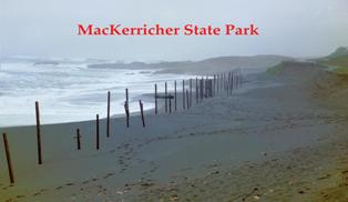 MacKerricher State Park
MacKerricher State Park stretches 7 miles along the coastline of Mendocino County just north of the settlement of Fort Bragg. The park topography consists of coastal bluffs, dunes, and a small lake, Lake Cleone, that empties into the ocean at Laguna Point (Schulz 1985).
Archaeological data from 1857 to 1956 indicates that prehistoric site types include shell middens, shell scatters and lithic. There are five sea vessels that are reported to be lost in the underwater park.
Marine Artifacts of Note in Park:
The park is littered with reminders of both the rich natural and cultural resources of the area relating to the sea. Of special note culturally are the remnant guide wire pins driven into the rocky shoreline that once held the wire lumber chute and wharf underpinnings. The line of railroad rails along the beach bear mute testimony to human effort to curb the natural beach erosion and the sheer size of the support timbers of the bike and pedestrian overpass reflect the once abundant lumber resource and its role in the area economy.
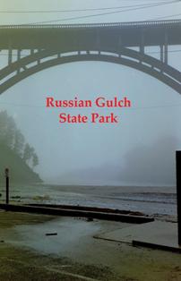 Russian Gulch State Park
Russian Gulch State Park is located south of Fort Bragg approximately 10 miles. Highway 1 crosses the mouth of the gulch forming a picturesque arch. On the headland at the mouth of Russian Gulch is a blow-hole known as the “Devil’s Punch Bowl. While the underwater park extends out around the northern headland, the shore side park extends approximately three miles inland along the creek through the heavily wooded canyon.
Archaeological data from 1883 to 1922 indicates that prehistoric site types include shell middens. There are four sea vessels that are reported to be lost in the underwater park.
Marine Artifacts of Note in Park:
The densely wooded nature of the park and its picturesque blow-hole bear little trace of human occupation. However, of special note culturally are the anchor, chain and vessel transom piece recovered within the underwater park by sport divers and now displayed on the front lawn of the DPR Mendocino District Headquarters.
The 6 ft tall, iron anchor has a folding stock and shackle placing it historically in the second half of the 19th century. The salt corrosion on the iron and the broken arm and fluke suggest that it had been underwater for a long period of time before removal and that the anchor was probably embedded in to reef when removed; thus the broken arm. Lying next to the anchor is a length of iron chain associated with sea-going vessels. The link style on the chain is oblong single link. The size and oval shape of the individual links place the chain circa mid-19th century. A short fragment of starboard, transom cap-rail leans against the anchor. The fragment still retains remnants of paint and curvature of the transom. The piece could possibly be off a schooner or fishing vessel.
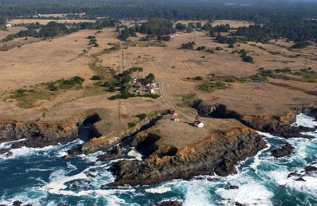 Point Cabrillo Light Station
The Point Cabrillo Light Station preserve occupies a spectacular headland thrusting out into the Pacific Ocean. It is comprised of the lighthouse and three original lightkeepers’ houses and outbuildings. Although Point Cabrillo was surveyed by the U. S. Lighthouse Service in 1873, construction of the Light Station didn't begin until after the 1906 earthquake. The demand for lumber to rebuild San Francisco meant that maritime commerce on the north coast was at an all time high and a Lighthouse was critical to the safety of the ships and their valuable cargo. Construction of the Light Station began in 1908, and the lens was illuminated for the first time on June 10,1909, under head keeper Wilhelm Baumgartner.
Marine Artifacts of Note in the Park:
In 1850, the Baltimore-built Clipper "Frolic," en-route to Gold-Rush San Francisco from China, wrecked on a reef just north of today's lighthouse. Her story is among the most fascinating in California shipwreck history, and was critical in to consideration to designate Point Cabrillo as a state underwater park. The Frolic settled in a cove at the north end of what is now the Preserve property and is dubbed "the most significant shipwreck on the west coast" by historians. Watch our new Mapping the "Frolic" video.
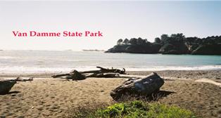 Van Damme State Park
Van Damme State Park and the historic community of Little River wrap around the bluffs of the underwater park at Van Damme, which encompasses the immediate small cove or doghole. Fern Canyon cuts inland along the banks of Little River terracing out into the famous Mendocino pygmy cypress forest.
Archaeological data from 1874 to 1905 indicates that prehistoric site types include shell middens. There are six sea vessels that are reported to be lost in the underwater park
Marine Artifacts of Note in Park:
Located near the visitor’s center is a large, iron kedging anchor. Strapped to a wooden post with iron wheels, the anchor is of the folding stock variety. The shackle at the top of the anchor places the date of the artifact in the second half of the 19th century.
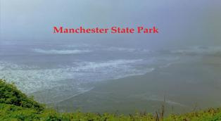 Manchester State Park
Manchester State Park stretches approximately 3.5 miles along the sand dunes and bluffs with intermittent marshland and numerous small creeks. Just to the south of the park is the Lighthouse at Point Arena. The entire onshore portion of the park runs along the western side of Highway 1 and is just north of the town of Point Arena. The north end of the park is bounded by Alder Creek. The 3, 782 acre block of park off shore includes the navigationally treacherous Point Arena wash rock at the southwestern tip of the park.
Archaeological data from 1858 to 1949 indicates that prehistoric site types include lithnic scatter. Six known shipwrecks are in the park and 34 sea vessels are reported to have been lost in the underwater area.
Marine Artifacts of Note in Park:
Although no maritime artifacts are readily apparent in the park, a numerous shipwreck artifacts are on display at the Point Arena Light house that is managed by the National Lighthouse Association. Among the items on display is a lifeboat off the Sea Foam. Local recreational scuba divers have reported finds relating to the 1949 British freighter shipwreck, Pacific Enterprise, just off shore in the underwater park (Barry and Foster n.d.)
 Salt Point State Park
Salt Point State Park runs along the rocky coastal geologic uplift from just north of Stump Cove south to just above the mouth of Wildcat Creek. The ridge running along the eastern edge of the Park is part of the San Andreas Fault. Rocky cliffs and tiny inlets are the signature of the State Park. Within the underwater park area of Gerstle Cove are two areas designated for their biological significance and pristine natural beauty.
Archaeological data from 1861 to 1926 indicates that there are a number of prehistoric site types including Kashia Pomo settlements. One known shipwreck is in the park, however, 24 sea vessels are reported to have been lost in the underwater area.
Marine Artifacts of Note in Park:
Remnant stone blanks litter the cliff edge around Gerstle Cove and iron pins mark where the lumber and loading chutes once stood. At the south side of the Gerstle Cove a large square indent in the stone marks the location of the second lumber chute counter weight. Several iron objects relating to the shipping activities of Salt Point are on display outside the Visitor’s Center. At the entrance to the park is a wrought, iron anchor of the folding stock type. The anchor is over 7 ft. tall with an arm span of 5 ft. The ring at the top of the anchor places it historically in the first half of the 19th century, making it one of the oldest anchors on display in the park system. According to rangers at the park, the anchor was originally recovered from the waters off Fort Ross Cove and latter moved to Salt Point. Of special note is the still visible remains of the freighter, Norlina, run onto the rocky shore upon sinking in 1926. Although lodged in the dynamic surge zone immediately offshore, the shipwreck can be accessed by boat or off the cliffs in calm water.
 Fort Ross Historic State Park
Fort Ross Historic State Park represents the multi-cultural diversity of California’s past. Characterized by sloping woodland bluffs and step rocky cliffs the park encompasses two coves , one of which has a protected beach. Spanning Highway 1, the park extends east into the foothills and both north and south across the bluff from the historic fort. The underwater park extends around the Northwest Cape to Clam Beach and around the southern headland into the next cove.
Archaeological data from 1872 to 1908 indicates that there are prehistoric site settlements in the park. One known shipwreck is in the park, and 10 sea vessels are reported to have been lost in the underwater area.
Marine Artifacts of Note in Park:
The South Cove is archaeologically rich with the remains of the early shipping industries associated with Fort Ross. The top of the bluff of the North Cove and the rocks along its fact are riddled with remnant iron pins reflecting the presence of the lumber chute and wharf in the latter part of the 19th century and early 20th century. Fragments of light rail are still present on the rocky beach of the North Cove bearing mute testament to the railway that once connected the surrounding cliffs with the wharf (Beeker 2002).
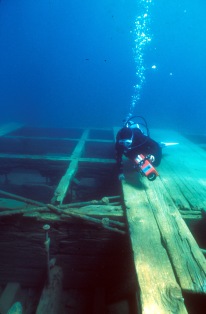
The wreck of the steamship Pomona lies in an east-west orientation, just inshore of the large wash-rock, and is marked by a historic shipwreck buoy, (Beeker 2002). The vessel has been archaeologically investigated and nominated for inclusion in the National Register of Historic Places. A waterproof map of the wreck site is available for recreational scuba divers.
 Sonoma Coast State Beach
Sonoma Coast State Beach is a 13 mile, contiguous strand of 11 beaches extending from Bodega Headlands at its southern boundary to the Russian River in the north. Rocky bluffs separate the beaches and sloping coastal terraces bound the park on the east. The underwater park runs the entire length of park paralleling the coastline at the prescribed 1,000 feet from the shoreline.
Archaeological data from 1849 to 1953 indicates that there are 38 prehistoric sites in the park, including settlements and shell middens. Though there are no know shipwrecks in the park, research indicates that there could be as many as 17 sea vessels that might have been lost in the underwater area.
Marine Artifacts of Note in Park:
Although Sonoma Coast State Beach is generally regarded for its surfing and kayaking, there are several noteworthy maritime cultural aspects. Duncan’s Landing at the northern end of the park has numerous iron pins noting the presence of the once prosperous doghole. Numerous historic barns and buildings still standing within the park reflect shipwright construction techniques and reveal the extent of the integration of the maritime industries in the communities of the coast.
The World War II coastal gun emplacement at Bodega Headlands reflects the historic military protective measures erected along the coast. A scattering of shell casings inland reveal that during World War II the area was used by the Coast Guard for target practice.
 Emerald Bay State Park
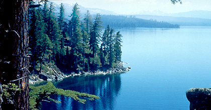
Located on the western shore of Lake Tahoe north, Emerald Bay is a fjord embayment and has long been recognized for its spectacular natural beauty. High Sierra escarpments plunge into the narrow bay and Fannette Island dots the bay’s center. At the head of the bay is the historic residence known as Vikingsholm. The underwater park extends out, around the entrance to the bay and includes Rubicon Point and Eagle Point.
Archaeological data from 1930s indicates that prehistoric site includes bedrock mortars. Six known shipwrecks are in the park and 8 other vessels are reported to have been lost in the underwater area.
Marine Artifacts of Note in Park:
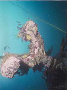
Emerald Bay is one of California’s underwater parks where extensive underwater archaeology has occurred. The two barges, resting on the south-side of the bay, have been visited by recreational scuba divers for years. However, in the early 1990s DPR in collaborations with other institutions and private industry began a systematic study of the submerged cultural resources of the bay. These barges were the first focus of the on-going study.
Today, the barges are located with an historic site, marker buoy and marked with an underwater monument. A detailed waterproof map of the barges and information guide is available for divers. The barges were built locally on the lake and most likely served a number of purposes, which may have included, car ferrying, construction material transport and general goods transport. Whatever the purpose of the barges they were purposely scuttled atop the garbage dump for Kirby’s Resort, located directly across the bay (Smith 1991).
Just offshore of boat camp, the historic site of Kirby’s Resort, are the remains of what is known as “the miniature fleet.” These four, small craft, sunk at their moorings were once available to the Kirby guests for exploration of the bay. Included among the sunken fleet are a hard-chine skiff, a metal hourglass stern rowboat, a kayak and a wooden rowboat (Beeker 2001). Modern moorings and buoys are arrayed around the contemporary boat camp, however none of "the miniature fleet" are designated historic site marker buoys. Visit Emerald Bay State Park.
 D. L. Bliss State Park
The grandeur of D. L Bliss State Park and its setting is a product of successive upheavals of the mountain-building processes that raised the Sierra Nevada. From promontories such as Rubicon Point in D.L. Bliss State Park you can see over one hundred feet into the depths of Lake Tahoe. On the crest of Eagle Falls in Emerald Bay State Park, you can see a brilliant panorama of Emerald Bay, Fannette Island, Lake Tahoe, and the distant Nevada shore.
The park is named for a pioneering lumberman, railroad owner, and banker of the region. The D.L. Bliss family donated 744 acres to the State Park system in 1929.
Known Prehistoric Sites:
Types:
Known Shipwrecks:
Reported Vessel Losses:
Date Range:
Marine Artifacts of Note in Park: TBA
Visit D.L. Bliss State Park.
 Mono Lake State Reserve
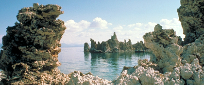
Located in the Mono Basin near the Sierra town of Lee Vining, Mono Lake is one of the oldest lakes in North America; 500,000 years old. The lake’s age, elevated salinity and lava tufts make it one of the most interesting and scenic locations in California.
Known Prehistoric Sites:
Types: settlements, quarries, rock art
Known Shipwrecks: 0
Reported Vessel Losses: 1
Date Range: 1880
Marine Artifacts of Note in Park: TBA
Visit Mono Lake State Reserve.
 Point Lobos State Reserve
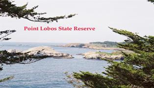
Point Lobos State Reserve is located 7 miles south of Monterey on a rocky promontory. The reserve overlaps several other reserves including the Monterey Bay National Marine Sanctuary, the California Sea Otter Game Refuge, and the Point Lobos Reserves designated for their biological and ecological significance. Included in the reserve is Whaler’s Cove, Blue Fish Cove, Granite Point and Cannery Point, as well as Gulilemont Island and numerous pinnacles just offshore. The rugged shoreline is riddled with small caves that are accessible to divers in calm seas.
Archaeological data from 1845 to 1974 indicates that there are 34 prehistoric sites in the park, including shell middens, settlement and lithic scatter. There are 12 sea vessels that are reported to be lost in the underwater park.
Marine Artifacts of Note in Park:
Turning anchors still located underwater and remnant iron pins, along with the historic Whaler’s Cabin available for visitor and diver to explore (Rosenberg 1995). The Whaler’s Cabin has been converted into an informative interpretive center that explores the whaling and abalone industry, as well as the overall system of coastal dogholes. The museum is an excellent model of interpretation and explanation with regard to the maritime history of coastal California.
Although not yet located, the pre Gold Rush era shipwreck Star of the West is purported to lie within the underwater park. The age of the wreck and the notorious story associated with its loss make it one of the most sought after maritime shipwreck sites in the state. Diving in the Marine Reserve is restricted in number and by reservation.